IMAGES TAKEN NEAR TO
Sandhurst Place, SHEFFIELD, S10 1HU
Introduction
This page details the photographs taken nearby to Sandhurst Place, S10 1HU by members of the Geograph project.
The Geograph project started in 2005 with the aim of publishing, organising and preserving representative images for every square kilometre of Great Britain, Ireland and the Isle of Man.

There are currently over 7.5m images from over14,400 individuals and you can help contribute to the project by visiting https://www.geograph.org.uk
Image Map (Loading...)


Getting Data...Please wait
Leaflet Map data © OpenStreetMap
Images are licensed for reuse under creativecommons.org/licenses/by-sa/2.0
Notes
- Clicking on the map will re-center to the selected point.
- The higher the marker number, the further away the image location is from the centre of the postcode.
Image Listing (167 Images Found)
Images are licensed for reuse under creativecommons.org/licenses/by-sa/2.0
Image
Details
Distance
1

"Save me!"
Campaign to save Sheffield's street trees.
Image: © David Martin
Taken: 7 Jul 2018
0.01 miles
2
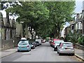
Western Road, Crookes
Looking down the tree–lined road towards School Road. To the right is suburban housing, to the left, Westways School, the former Western Road Secondary Modern School.
Image: © Dave Hitchborne
Taken: 26 Aug 2008
0.02 miles
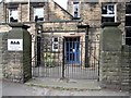
3
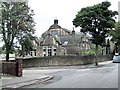
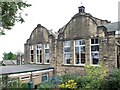
The former Western Road Secondary Modern School, Crookes
This is now Westways, seen at its position at the corner of Western Road and Mona Avenue. The school was built as three separate buildings for seniors, juniors and infants. The senior school is further separated from the others by a high retaining wall, behind which the land was built up from the land below to lessen the slope of the two playgrounds.
Image: © Dave Hitchborne
Taken: 26 Aug 2008
0.02 miles
4
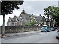
The former Western Road Secondary Modern School, Crookes
The school is now Westways. As I remember it, the school had a rectangular hall, which was almost enclosed by the glass and panelled partitions of the classrooms. A small stage stood by the northeast wall. The hall was used for assembly, physical education and school meals. There was a fire exit at each corner and I got the job of painting FIRE EXIT A, B, C & D above each door. The school had four ‘houses’ Bronte, Chantry, Firth and Nightingale. The senior school was on the corner of Western Road and Mona Avenue, the Juniors and Infants was accessed from Mona Avenue. I went to all three, from the years 1945 to 1957, and hated it.
Image: © Dave Hitchborne
Taken: 26 Aug 2008
0.02 miles
5
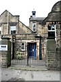
The former Western Road Secondary Modern School, Crookes
The main entrance/exit to the school is on Mona Avenue. This was the original entrance/exit, which is on Western Road and faces the houses opposite. There is a fire exit from the building, further down Western Road. When I did my schooling here, back in the ‘40s and ‘50s, there were another two on the opposite side of the building. All led from the hall, which was used for assembly, school meals and P.E.
P.E. was my worst nightmare, but I nearly always got away without doing it. I also ‘escaped’ playing football, except for the once, as ‘they’ quickly realised I had no concept of the game and probably for that same reason, I never ever got to play cricket. When we were all marched off to the playing fields on the Bolehills for cricket and football, I was made to walk or run around the field. ‘They’ never realised my potential for running though, as I could really shift, especially when it was very cold. ‘They’ were obviously too interested in the game, to see me running my little legs off.
The school is now called Westways.
Image: © Dave Hitchborne
Taken: 26 Aug 2008
0.02 miles
6
The former Western Road Secondary Modern School, Crookes
The Former Western Road Secondary Modern School, Crookes
The main entrance/exit to the school is on Mona Avenue. This was the original entrance/exit, which is on Western Road and faces the houses opposite. There is a fire exit from the building, further down Western Road. When I did my schooling here, back in the ‘40s and ‘50s, there were another two on the opposite side of the building. All led from the hall, which was used for assembly, school meals and P.E.
The school is now called Westways.
Image: © Dave Hitchborne
Taken: 26 Aug 2008
0.02 miles
7
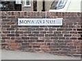
Mona Avenue, Crookes
Road sign. The avenue runs from Western Road down to Mona Road and has access to Westways, the local school, formerly known as Western Road Secondary Modern School. http://www.geograph.org.uk/photo/1206812
Image: © Dave Hitchborne
Taken: 26 Aug 2008
0.03 miles
8
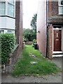
Western Road, Crookes
There used to be a way through to Cobden View Road from here. It was used for many years by the children of Western Road Comprehensive School and it makes me wonder how it was allowed to be blocked off. What happened to the Right of Way?
Image: © Dave Hitchborne
Taken: 26 Aug 2008
0.03 miles
9
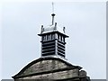
The former Western Road Secondary Modern School, Crookes
The spiked finial at the top of the bell tower is a lightning rod, which is especially made of copper. Basically, this is attached to a strap like bare copper conductor, which is in turn attached to the earth electrode below. The earth electrode is usually a large metal plate buried underground. The purpose of all this is to direct the current from a lightning strike and discharge it safely into the ground, so protecting the structure. It is necessary to make sure that the conductor is kept well away from other metalwork, electric cabling, gas and other inflammable materials.
Image: © Dave Hitchborne
Taken: 26 Aug 2008
0.03 miles
10
The former Western Road Secondary Modern School, Crookes
The extension built serves as the main entrance from Mona Avenue. The original entrance was from Western Road. The playground appears to have been enhanced with a garden.
Image: © Dave Hitchborne
Taken: 26 Aug 2008
0.03 miles