IMAGES TAKEN NEAR TO
Sackville Road, SHEFFIELD, S10 1GU
Introduction
This page details the photographs taken nearby to Sackville Road, S10 1GU by members of the Geograph project.
The Geograph project started in 2005 with the aim of publishing, organising and preserving representative images for every square kilometre of Great Britain, Ireland and the Isle of Man.

There are currently over 7.5m images from over14,400 individuals and you can help contribute to the project by visiting https://www.geograph.org.uk
Image Map
Images are licensed for reuse under creativecommons.org/licenses/by-sa/2.0
Notes
- Clicking on the map will re-center to the selected point.
- The higher the marker number, the further away the image location is from the centre of the postcode.
Image Listing (197 Images Found)
Images are licensed for reuse under creativecommons.org/licenses/by-sa/2.0
Image
Details
Distance
1
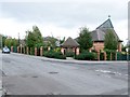
The Church of St Vincent, Crookes
The church stands on the site of the former Sheffield Corporation Tram Depot http://www.chrishobbs.com/pickmererd.htm
The six–road depot serviced a part of the fleet of about 400 vehicles.
It lasted until the whole tramway service was withdrawn on 8th October 1960.
Image: © Dave Hitchborne
Taken: 26 Aug 2008
0.05 miles
3
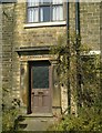
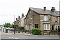
Crookes House
Doorway of Crookes House, Sackville Rd, Crookes.
Image: © Andrew H
Taken: Unknown
0.08 miles
4
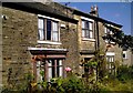
Crookes House
Crookes House, Sackville Rd, Crookes
This house once had large grounds which are all now taken up by the shops and houses which surround it.
Image: © Andrew H
Taken: Unknown
0.08 miles
5
School Road, Crookes
Typically, the roads run steeply out of Crookes. This one drops down to Commonside and the route from Intake to Walkley, a former tramway.
Image: © Dave Hitchborne
Taken: 26 Aug 2008
0.08 miles
6
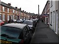
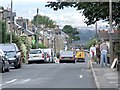
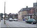
Crookes, Crookes
Just up the road from the post office is this block of terraced houses. Rather than stagger them in height on this slightly sloping ground, they have all been built level with one another, which has meant the use of an ever increasing height in steps at the front doors. Just beyond the red car, the pavement has been extended out into the road to create a parking area for these houses. Outside the Dental Surgery trees have been planted and a litter bin has been installed.
Across the road, just above the Wesley Hall Methodist Church, is a patch of greenery where in 1935 there once stood a Corn Dealers and a Dentists. This building later sold pikelets and oatcakes, the latter being a particular favourite of mine.
Between where the new build is now and the Ball Inn, there used to be terraced houses and shops. In 1965, the shops included a double–fronted shop, which at 155/157 was A Revill’s Grocers Shop and at 163 Bertha Tyler’s Herbalist Shop. During the ‘50s, on occasional Sundays, I used to be sent to the grocers shop because we had run out of something or other. The laws about selling things on a Sunday were very peculiar back then. They would probably allow me to buy a loaf of bread and a packet of cigarettes, but not a bar of soap, or something like that.
Bertha’s Herbalist shop was a pokey little place. To the left, as you walked in, was an old school type bench. Ahead was a counter, a portion of which lifted for the shopkeeper to get through either way. Beyond it was the back room. The wall between and the one to the right was shelved and contained many stone and glass jars of herbs and spices. The counter continued to the right in an L–shape. The air was filled with a mixture of the smell of cinnamon, liquorice, sarsaparilla and Vimto. As a lad, I often went in on a cold winter’s night, for a warm Vimto. The shopkeeper went into the back room to boil the kettle.
Image: © Dave Hitchborne
Taken: 26 Aug 2008
0.08 miles
7
Crookes, Crookes
Just above the Wesley Hall Methodist Church, is this patch of greenery where in 1935 there once stood a Corn Dealers and a Dentists. This building later sold pikelets and oatcakes, the latter being a particular favourite of mine. Between where the new build is now and the Ball Inn, there used to be terraced houses and shops. In 1965, the shops included a double–fronted shop, which at 155/157 was A Revill’s Grocers Shop and at 163 Bertha Tyler’s Herbalist Shop. During the ‘50s, on occasional Sundays, I used to be sent to the grocers shop because we had run out of something or other. The laws about selling things on a Sunday were very peculiar back then. They would probably allow me to buy a loaf of bread and a packet of cigarettes, but not a bar of soap, or something like that.
Bertha’s Herbalist shop was a pokey little place. To the left, as you walked in, was an old school type bench. Ahead was a counter, a portion of which lifted for the shopkeeper to get through either way. Beyond it was the back room. The wall between and the one to the right was shelved and contained many stone and glass jars of herbs and spices. The counter continued to the right in an L–shape. The air was filled with a mixture of the smell of cinnamon, liquorice, sarsaparilla and Vimto. As a lad, I often went in on a cold winter’s night, for a warm Vimto. The shopkeeper went into the back room to boil the kettle.
Image: © Dave Hitchborne
Taken: 26 Aug 2008
0.08 miles
8

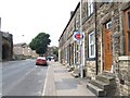
Pickmere Road, Crookes
The road opposite was a tramway and half way down the road was the Crookes, Sheffield Corporation Tram Depot, one of eight, which was opened in 1919. The depot was responsible for servicing a part of the fleet of about 400 vehicles.
The road is now a cul-de-sac.
The road to the right is School Road, which leads to Commonside.
Image: © Dave Hitchborne
Taken: 26 Aug 2008
0.09 miles
9
Pickmere Road, Crookes - panorama #2 of 2
The road opposite was a tramway and half way down the road was the Crookes, Sheffield Corporation Tram Depot, one of eight, which was opened in 1919. The depot was responsible for servicing a part of the fleet of about 400 vehicles.
The road is now a cul-de-sac.
The road to the right is School Road, which leads to Commonside.
Image: © Dave Hitchborne
Taken: 19 Jul 2012
0.09 miles
10
Pickmere Road, Crookes
Until 8th October 1960, this road was a tram route and had a tram depot on it. Now the road is a cul-de-sac and no longer has access onto the main road at this point. To the right is the local post office.
Ahead, undergoing renovation, is the former Crookes Endowed School.
Image: © Dave Hitchborne
Taken: 26 Aug 2008
0.09 miles