IMAGES TAKEN NEAR TO
School Road, SHEFFIELD, S10 1GR
Introduction
This page details the photographs taken nearby to School Road, S10 1GR by members of the Geograph project.
The Geograph project started in 2005 with the aim of publishing, organising and preserving representative images for every square kilometre of Great Britain, Ireland and the Isle of Man.

There are currently over 7.5m images from over14,400 individuals and you can help contribute to the project by visiting https://www.geograph.org.uk
Image Map
Images are licensed for reuse under creativecommons.org/licenses/by-sa/2.0
Notes
- Clicking on the map will re-center to the selected point.
- The higher the marker number, the further away the image location is from the centre of the postcode.
Image Listing (182 Images Found)
Images are licensed for reuse under creativecommons.org/licenses/by-sa/2.0
Image
Details
Distance
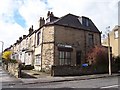
1
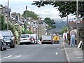
School Road, Crookes
Typically, the roads run steeply out of Crookes. This one drops down to Commonside and the route from Intake to Walkley, a former tramway.
Image: © Dave Hitchborne
Taken: 26 Aug 2008
0.03 miles
2
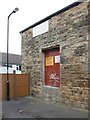
Wesley Lane, Crookes
The doorway and step height has been raised. Probably makes it easier to load and offload bags of plaster.
Image: © Dave Hitchborne
Taken: 26 Aug 2008
0.05 miles
3
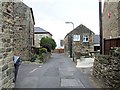
Wesley Road, Crookes
To the right, is Willson & Dowling Decorative Plasterers Ltd. This works has seen other trades including garage, upholstery and joinery.
Image: © Dave Hitchborne
Taken: 26 Aug 2008
0.05 miles
4
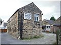
Wesley Lane, Crookes
Present day use for this old works, is Willson & Dowling Decorative Plasterers Ltd. It's seen a variety of professions, from garage, to upholstery and joinery. A friend tells me that it started life as, The Model Dairy Farm. A date stone reads, MODEL DAIRY FARM 1892.
The lane runs from Crookes, down to the wooden fence and then does a ninety degree turn to School Road, so it can be approached from two directions. This has an advantage in that a rear side entrance door http://www.geograph.org.uk/photo/1148713 can be reversed up to for loading and offloading. Not a lot of room for manoeuvring though.
Image: © Dave Hitchborne
Taken: 26 Aug 2008
0.06 miles
5
Junction of School Road and Clementson Road, Crookes
An area of mainly student housing
Image: © Sue Morgan
Taken: 20 Mar 2004
0.06 miles
6
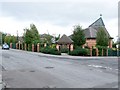
The Church of St Vincent, Crookes
The church stands on the site of the former Sheffield Corporation Tram Depot http://www.chrishobbs.com/pickmererd.htm
The six–road depot serviced a part of the fleet of about 400 vehicles.
It lasted until the whole tramway service was withdrawn on 8th October 1960.
Image: © Dave Hitchborne
Taken: 26 Aug 2008
0.06 miles
7
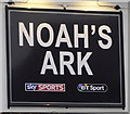
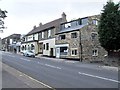
Noah's Ark, Crookes (road), Sheffield
http://www.geograph.org.uk/photo/5657324
Image: © Ian S
Taken: 20 Jan 2018
0.06 miles
8
Noah?s Ark, Crookes
The relief work on the pub wall says: –
NOAH’S ARK
TENNANTS’ CELEBRATED
ALES & STOUTS.
The small single–storey building below the sign is, Superior Student Accommodation, which in the ‘60s used to be P M Hopkinson, Tobacconist.
Image: © Dave Hitchborne
Taken: 26 Aug 2008
0.06 miles
9

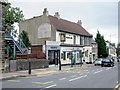
Noah's Ark, Crookes
Between Wesley Lane and School Road is the Noah's Ark, one of the many pubs in the area.
Above Wesley Lane is The Works, Beauty Studio – Noah’s Ark, Public House – Superior Student Accommodation, Local Letting Agent – R Hayman, Butcher’s Shop.
Back in the sixties, The Works used to be C Thomas Ltd., Bakers and next door to that, before it became a part of the Noah’s Ark, was Winfield & Sons Ltd., Decorators. The property above the pub was P M Hopkinson, Tobacconist. The corner shop has remained a Butcher’s Shop, but back then, it belonged to F Burrows & Sons.
The pub is opposite a path to the Church of St Thomas.
Image: © Dave Hitchborne
Taken: 26 Aug 2008
0.06 miles
10
Crookes, Crookes
Above Wesley Lane is The Works, Beauty Studio – Noah’s Ark, Public House – Superior Student Accommodation, Local Letting Agent – R Hayman, Butcher’s Shop.
Back in the sixties, The Works used to be C Thomas Ltd., Bakers and next door to that, before it became a part of the Noah’s Ark, was Winfield & Sons Ltd., Decorators. The property above the pub was P M Hopkinson, Tobacconist. The corner shop has remained a Butcher’s Shop, but back then, it belonged to F Burrows & Sons.
Image: © Dave Hitchborne
Taken: 26 Aug 2008
0.06 miles