IMAGES TAKEN NEAR TO
The Nook, SHEFFIELD, S10 1EJ
Introduction
This page details the photographs taken nearby to The Nook, S10 1EJ by members of the Geograph project.
The Geograph project started in 2005 with the aim of publishing, organising and preserving representative images for every square kilometre of Great Britain, Ireland and the Isle of Man.

There are currently over 7.5m images from over14,400 individuals and you can help contribute to the project by visiting https://www.geograph.org.uk
Image Map (Loading...)


Getting Data...Please wait
Leaflet Map data © OpenStreetMap
Images are licensed for reuse under creativecommons.org/licenses/by-sa/2.0
Notes
- Clicking on the map will re-center to the selected point.
- The higher the marker number, the further away the image location is from the centre of the postcode.
Image Listing (124 Images Found)
Images are licensed for reuse under creativecommons.org/licenses/by-sa/2.0
Image
Details
Distance
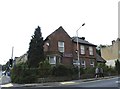
1
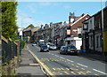
Barber Road above Crookesmoor Road
Looking uphill with various shops on the right hand side of the street.
Image: © Andrew Hill
Taken: 25 Jun 2011
0.03 miles
2
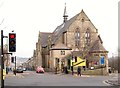
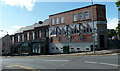
Former Crookes Valley Methodist Church, Sheffield
This Grade II-listed building was constructed as St John’s Wesleyan Methodist Church and School in 1881 at a cost of £7000. However, when St Luke’s Wesleyan Methodist Church, Northfield Road, Crookes closed in 1965, and its congregation joined forces to share this building, it was renamed Crookes Valley Methodist Church. The ‘new’ church closed in 2003 and after standing empty for years, it was converted into private residential apartments of varying sizes and renamed Heritage Hall & Lodge. Crookes and Broomhill can be reached behind the photographer via the upper section of Crookesmoor Road. In the opposite direction Crookesmoor Road descends towards the part of Sheffield where the Royal Infirmary once stood, on Langsett Road.
Image: © David Hallam-Jones
Taken: 19 Feb 2018
0.06 miles
3
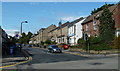
Crookesmoor Road
Looking along the largely residential street from the Barber Road junction.
Image: © Andrew Hill
Taken: 25 Jun 2011
0.07 miles
4
Crookes Valley Junction, Crookes Valley, Sheffield - 2
Crookesmoor Road runs from top to bottom, Crookes Valley Road runs off to the left.
The car is emerging from Barber Road.
See also ...
Image
Image
Image: © Terry Robinson
Taken: 1 Sep 2012
0.07 miles
5
Shops on Barber Road
Looking across Barber Road with Commonside heading away on the right. The jewellers at the top on the corner was formerly a bank.
Image: © Andrew Hill
Taken: 25 Jun 2011
0.07 miles
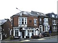
6
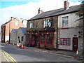
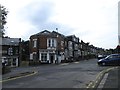
The Hallamshire House Public House
19th Century public house and old coaching inn on situated on Commonside. Don't let the unsightly traffic lights and cones detract you too much from this pub which is one of the most atmospheric and unpretentious real ale establishments in the city. At the time of posting the current proprietors had also just celebrated their 30th anniversary at the helm.
Image: © Jonathan Clitheroe
Taken: 12 Oct 2010
0.07 miles
7
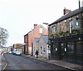
Hallamshire House, Commonside, Sheffield
The junction of the lower end of Commonside with Barber Road can be glimpsed in the distance. Herded animals, on their way to the former cattle market near to the former Victoria Railway Station, may well have been 'rested' in this area i.e. Common-side. (See: https://www.sheffieldhistory.co.uk/forums/topic/16673-baaa/). "The Closed Shop" -
a gastropub - is situated behind the photographer at the junction with Hands Lane.
Image: © David Hallam-Jones
Taken: 19 Feb 2018
0.07 miles
8
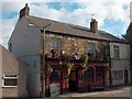
"The Hallamshire House" at Commonside, Sheffield 10
Image: © Neil Theasby
Taken: 24 Oct 2010
0.07 miles
9
Crookes Valley Medical and Dental Practice, Barber Road, Crookes Valley, Sheffield
Situated on Crookes Valley Junction ... see also ...
Image
Image: © Terry Robinson
Taken: 1 Sep 2012
0.07 miles
10
Second Hand Centre, Crookes Valley Road, Crookes Valley, Sheffield
Image: © Terry Robinson
Taken: 1 Sep 2012
0.07 miles