IMAGES TAKEN NEAR TO
Horse Bridge Close, DAGENHAM, RM9 6YQ
Introduction
This page details the photographs taken nearby to Horse Bridge Close, RM9 6YQ by members of the Geograph project.
The Geograph project started in 2005 with the aim of publishing, organising and preserving representative images for every square kilometre of Great Britain, Ireland and the Isle of Man.

There are currently over 7.5m images from over14,400 individuals and you can help contribute to the project by visiting https://www.geograph.org.uk
Image Map
Images are licensed for reuse under creativecommons.org/licenses/by-sa/2.0
Notes
- Clicking on the map will re-center to the selected point.
- The higher the marker number, the further away the image location is from the centre of the postcode.
Image Listing (19 Images Found)
Images are licensed for reuse under creativecommons.org/licenses/by-sa/2.0
Image
Details
Distance
1
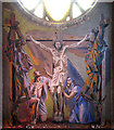
St Martin, Goresbrook Road, Dagenham - Painting
Above high altar
Image: © John Salmon
Taken: 9 Mar 2005
0.07 miles
6
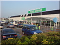
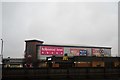
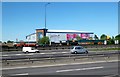
Asda, Dagenham
On Merrielands Crescent, Ripley Rd, Dagenham, RM9 6SJ
Image: © Danny P Robinson
Taken: 2 Jul 2009
0.15 miles
9
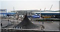
Goresbrook Road bridges The Gores
Rather hard to see with summer vegetation, this is where The Gores leaves Goresbrook Park.
Image: © Robin Webster
Taken: 25 Jun 2011
0.18 miles
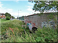
10

Goresbrook Road bridges The Gores
Rather hard to see with summer vegetation, this is where The Gores leaves Goresbrook Park.
Image: © Robin Webster
Taken: 25 Jun 2011
0.18 miles