IMAGES TAKEN NEAR TO
Burdetts Road, DAGENHAM, RM9 6XY
Introduction
This page details the photographs taken nearby to Burdetts Road, RM9 6XY by members of the Geograph project.
The Geograph project started in 2005 with the aim of publishing, organising and preserving representative images for every square kilometre of Great Britain, Ireland and the Isle of Man.

There are currently over 7.5m images from over14,400 individuals and you can help contribute to the project by visiting https://www.geograph.org.uk
Image Map
Images are licensed for reuse under creativecommons.org/licenses/by-sa/2.0
Notes
- Clicking on the map will re-center to the selected point.
- The higher the marker number, the further away the image location is from the centre of the postcode.
Image Listing (40 Images Found)
Images are licensed for reuse under creativecommons.org/licenses/by-sa/2.0
Image
Details
Distance
1

Goresbrook Road bridges The Gores
Rather hard to see with summer vegetation, this is where The Gores leaves Goresbrook Park.
Image: © Robin Webster
Taken: 25 Jun 2011
0.09 miles
2
Goresbrook Road bridges The Gores
Rather hard to see with summer vegetation, this is where The Gores leaves Goresbrook Park.
Image: © Robin Webster
Taken: 25 Jun 2011
0.09 miles
3
Path in Goresbrook Park
This path leads from Goresbrook Road towards Dagenham Avenue.
The path crosses The Gores (stream) running through the park
Image: © David Anstiss
Taken: 31 Mar 2013
0.11 miles
4
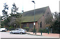
St Peter's Gorsebrook
This is St Peters Roman Catholic Church and its associated estate. It is located in the Gorsebrook Parade Environment Improvement Scheme. It stands directly opposite St Martins C of E Church.
Image: © Glyn Baker
Taken: 8 Sep 2005
0.11 miles
5
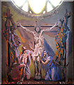
St Martin, Goresbrook Road, Dagenham - Painting
Above high altar
Image: © John Salmon
Taken: 9 Mar 2005
0.12 miles
6
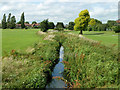
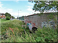
The Gores through Goresbrook Park
The brook or drain is mapped as The Gores, which was a new one on me! It discharges to the Thames nearly opposite Cross Ness.
Image: © Robin Webster
Taken: 25 Jun 2011
0.12 miles
7
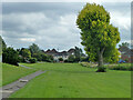
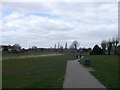
In Goresbrook Park, 2011
The south-eastern corner. The tarmac path on the left has since been dug up and a new path closer to the brook on the right substituted.
Image: © Robin Webster
Taken: 25 Jun 2011
0.13 miles
8
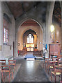
St Martin, Goresbrook Road, Dagenham - Lady Chapel
Image: © John Salmon
Taken: 9 Mar 2005
0.15 miles
9
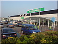
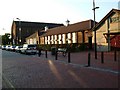
Asda, Dagenham
On Merrielands Crescent, Ripley Rd, Dagenham, RM9 6SJ
Image: © Danny P Robinson
Taken: 2 Jul 2009
0.16 miles