IMAGES TAKEN NEAR TO
Talbot Road, DAGENHAM, RM9 6HJ
Introduction
This page details the photographs taken nearby to Talbot Road, RM9 6HJ by members of the Geograph project.
The Geograph project started in 2005 with the aim of publishing, organising and preserving representative images for every square kilometre of Great Britain, Ireland and the Isle of Man.

There are currently over 7.5m images from over14,400 individuals and you can help contribute to the project by visiting https://www.geograph.org.uk
Image Map
Images are licensed for reuse under creativecommons.org/licenses/by-sa/2.0
Notes
- Clicking on the map will re-center to the selected point.
- The higher the marker number, the further away the image location is from the centre of the postcode.
Image Listing (48 Images Found)
Images are licensed for reuse under creativecommons.org/licenses/by-sa/2.0
Image
Details
Distance
6
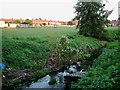
The Gorse Brook
This is the Gorse Brook that gives its name to the Gorsebrook area of the Becontree Estate. Its flood plain provides an area of green in the housing estate. The picture was taken near the bridge on Hedgemans Road and looks across Gorsebrook Park.
Image: © Glyn Baker
Taken: 8 Sep 2005
0.12 miles
8
NEW
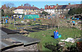
Hedgemans Road Allotments
Still early March and not much is growing yet. Blue bins are obviously a must have for the gardeners here.
Image: © Des Blenkinsopp
Taken: 3 Mar 2025
0.12 miles