IMAGES TAKEN NEAR TO
Hedgemans Road, DAGENHAM, RM9 6HD
Introduction
This page details the photographs taken nearby to Hedgemans Road, RM9 6HD by members of the Geograph project.
The Geograph project started in 2005 with the aim of publishing, organising and preserving representative images for every square kilometre of Great Britain, Ireland and the Isle of Man.

There are currently over 7.5m images from over14,400 individuals and you can help contribute to the project by visiting https://www.geograph.org.uk
Image Map
Images are licensed for reuse under creativecommons.org/licenses/by-sa/2.0
Notes
- Clicking on the map will re-center to the selected point.
- The higher the marker number, the further away the image location is from the centre of the postcode.
Image Listing (58 Images Found)
Images are licensed for reuse under creativecommons.org/licenses/by-sa/2.0
Image
Details
Distance
7
NEW
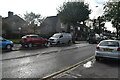
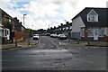
At the Junction
Hedgemans Road and Dagenham Avenue meet at quite a sharp angle. The triangle at the junction has been made into a small garden or plaza with seats and bits of wood and a sort of Yellow Brick Road through the middle.
A nice place to sit out on a day like this.
Image: © Des Blenkinsopp
Taken: 3 Mar 2025
0.09 miles
8
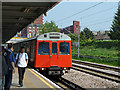
District Line train at Dagenham Heathway
A westbound train, composed of D78 stock.
Image: © Robin Webster
Taken: 24 Apr 2011
0.10 miles
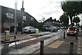
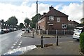
9
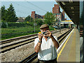
Dagenham Heathway station in the mirror
How these images are created.
Image: © Robin Webster
Taken: 24 Apr 2011
0.11 miles
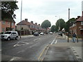
10
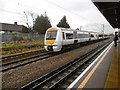
A C2C train passes Dagenham Heathway Underground station
The London, Tilbury & Southend Railway opened its line from Forest Gate via Barking and Dagenham Dock to Tilbury in 1854. In 1858 the company opened a cut off between Bow and Barking.
What is now the C2C line was opened in 1885 by the London, Tilbury & Southend Railway between Barking and Upminster, and a station was opened at Dagenham (East) the same year. No further stations opened on the line until Gale Street Halt (now Becontree) in 1926, followed by Hornchurch, Heathway (later renamed Dagenham Heathway from 1st May 1949) and Upney on 12th September 1932. On the same date as these stations opened in 1932, the District line was extended over new tracks alongside the existing line between Barking and Upminster. The present C2C line therefore dates from 1885 and the present District line from 1932.
This view from the up platform looks across the up District line towards the two C2C lines, with a train for Shoeburyness passing. Its next stop will be Upminster. Becontree is the next station in this direction.
Image: © Marathon
Taken: 9 Mar 2016
0.11 miles