IMAGES TAKEN NEAR TO
Raydons Road, DAGENHAM, RM9 5JR
Introduction
This page details the photographs taken nearby to Raydons Road, RM9 5JR by members of the Geograph project.
The Geograph project started in 2005 with the aim of publishing, organising and preserving representative images for every square kilometre of Great Britain, Ireland and the Isle of Man.

There are currently over 7.5m images from over14,400 individuals and you can help contribute to the project by visiting https://www.geograph.org.uk
Image Map
Images are licensed for reuse under creativecommons.org/licenses/by-sa/2.0
Notes
- Clicking on the map will re-center to the selected point.
- The higher the marker number, the further away the image location is from the centre of the postcode.
Image Listing (6 Images Found)
Images are licensed for reuse under creativecommons.org/licenses/by-sa/2.0
Image
Details
Distance
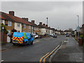
2
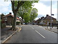
Osborne Road, Becontree
Part of the vast Becontree Estate, seen here in dismal weather. The junction in the foreground is with Halbutt Street; Alibon Road leads off to the right.
Image: © Stephen McKay
Taken: 13 Feb 2020
0.18 miles
4
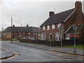
Fanshawe Crescent, Becontree
Seen from the junction with Barnmead Road, these houses are typical of the estate.
Image: © Stephen McKay
Taken: 13 Feb 2020
0.21 miles