IMAGES TAKEN NEAR TO
Maxey Road, DAGENHAM, RM9 5HS
Introduction
This page details the photographs taken nearby to Maxey Road, RM9 5HS by members of the Geograph project.
The Geograph project started in 2005 with the aim of publishing, organising and preserving representative images for every square kilometre of Great Britain, Ireland and the Isle of Man.

There are currently over 7.5m images from over14,400 individuals and you can help contribute to the project by visiting https://www.geograph.org.uk
Image Map
Images are licensed for reuse under creativecommons.org/licenses/by-sa/2.0
Notes
- Clicking on the map will re-center to the selected point.
- The higher the marker number, the further away the image location is from the centre of the postcode.
Image Listing (17 Images Found)
Images are licensed for reuse under creativecommons.org/licenses/by-sa/2.0
Image
Details
Distance
1
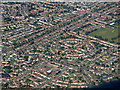
Valence Circle from the air
The circle is prominent from the air. Valence Park is on the right, Southwood Primary School https://www.southwoodprimary.co.uk/ on the left.
Image: © Thomas Nugent
Taken: 26 Aug 2019
0.08 miles
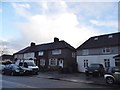
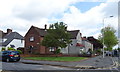
2
Beverley Road, Becontree
Beverley Road, on the Becontree Estate in east London.
Image: © Malc McDonald
Taken: 28 Aug 2017
0.13 miles
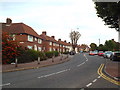
6
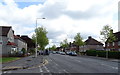
Wood Lane, Dagenham
Looking north east on the A124.
Image: © JThomas
Taken: 11 May 2019
0.17 miles
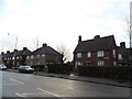
9
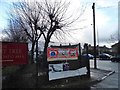
The entrance to the Cherry Tree pub, Becontree
Image: © David Howard
Taken: 5 Mar 2017
0.19 miles
10
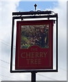
Sign for the Cherry Tree, Dagenham
See Image] for context.
Image: © JThomas
Taken: 11 May 2019
0.20 miles