IMAGES TAKEN NEAR TO
Gale Street, DAGENHAM, RM9 4UN
Introduction
This page details the photographs taken nearby to Gale Street, RM9 4UN by members of the Geograph project.
The Geograph project started in 2005 with the aim of publishing, organising and preserving representative images for every square kilometre of Great Britain, Ireland and the Isle of Man.

There are currently over 7.5m images from over14,400 individuals and you can help contribute to the project by visiting https://www.geograph.org.uk
Image Map
Images are licensed for reuse under creativecommons.org/licenses/by-sa/2.0
Notes
- Clicking on the map will re-center to the selected point.
- The higher the marker number, the further away the image location is from the centre of the postcode.
Image Listing (17 Images Found)
Images are licensed for reuse under creativecommons.org/licenses/by-sa/2.0
Image
Details
Distance
1
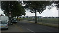
View of the rear of Jo Richardson Community School from Goresbrook Road
Looking south-southeast.
Image: © Robert Lamb
Taken: 23 Jul 2014
0.05 miles
2
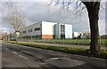
The Jo Richardson Community School, Becontree
Image: © David Howard
Taken: 19 Mar 2023
0.08 miles
3
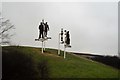
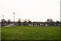
Local Heroes, Castle Green Recreation Ground
Image: © N Chadwick
Taken: 11 Jan 2018
0.08 miles
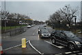
6
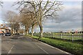
Gorsebrook Road, Becontree
By Castle Green
Image: © David Howard
Taken: 19 Mar 2023
0.13 miles
7
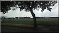
View of Access Self Storage on the A13 from Goresbrook Road
Looking south-southeast.
Image: © Robert Lamb
Taken: 23 Jul 2014
0.14 miles
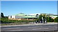
9
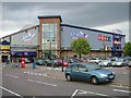
A Mecca for Bowling?
Gorsebrook Leisure Centre Dagenham showing the cultural delights of the East London/Essex borders.
Image: © Glyn Baker
Taken: 11 Aug 2005
0.16 miles