IMAGES TAKEN NEAR TO
Waterbeach Road, DAGENHAM, RM9 4AB
Introduction
This page details the photographs taken nearby to Waterbeach Road, RM9 4AB by members of the Geograph project.
The Geograph project started in 2005 with the aim of publishing, organising and preserving representative images for every square kilometre of Great Britain, Ireland and the Isle of Man.

There are currently over 7.5m images from over14,400 individuals and you can help contribute to the project by visiting https://www.geograph.org.uk
Image Map
Images are licensed for reuse under creativecommons.org/licenses/by-sa/2.0
Notes
- Clicking on the map will re-center to the selected point.
- The higher the marker number, the further away the image location is from the centre of the postcode.
Image Listing (20 Images Found)
Images are licensed for reuse under creativecommons.org/licenses/by-sa/2.0
Image
Details
Distance
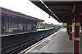
1
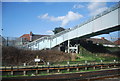
Footbridge over the District Line, Becontree
Image: © N Chadwick
Taken: 3 Mar 2012
0.19 miles
3
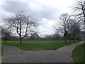
Path junction, Parsloes Park
A path from Gale Street divides here. A path leads left towards the sports pavilion and recreational grounds. The other path leads around the pond (hidden by the shrubs in the background).
Image: © David Anstiss
Taken: 31 Mar 2013
0.21 miles
7

Becontree station
The world famous London Transport 'Bullseye' roundel,
this time at Becontree station on the District Line.
Image: © Phillip Perry
Taken: 1 Aug 2010
0.22 miles
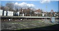
10
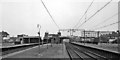
Becontree Station
View eastwards, towards Upminster, Southend-on-Sea and Shoeburyness. Tracks on right are ex-LT&S Fenchurch Street - Upminster - Southend - Shoeburyness line (the wires are up, but electric services did not begin until six months later). On the left are the LT District Line tracks to Upminster.
Image: © Ben Brooksbank
Taken: 12 May 1961
0.23 miles