IMAGES TAKEN NEAR TO
Rowlands Road, DAGENHAM, RM8 3DX
Introduction
This page details the photographs taken nearby to Rowlands Road, RM8 3DX by members of the Geograph project.
The Geograph project started in 2005 with the aim of publishing, organising and preserving representative images for every square kilometre of Great Britain, Ireland and the Isle of Man.

There are currently over 7.5m images from over14,400 individuals and you can help contribute to the project by visiting https://www.geograph.org.uk
Image Map
Images are licensed for reuse under creativecommons.org/licenses/by-sa/2.0
Notes
- Clicking on the map will re-center to the selected point.
- The higher the marker number, the further away the image location is from the centre of the postcode.
Image Listing (10 Images Found)
Images are licensed for reuse under creativecommons.org/licenses/by-sa/2.0
Image
Details
Distance
5
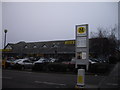
Morrisons supermarket Wood Lane Dagenham
Image: © PAUL FARMER
Taken: 6 Feb 2010
0.19 miles
6
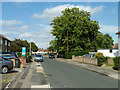
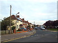
Thompson Road, Dagenham
The tree is on a tiny green at the corner with Heathway.
Image: © Robin Webster
Taken: 25 Jun 2011
0.20 miles
7
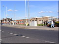
Seabrook Community Centre
Near the A124 Wood Lane
Image: © Geographer
Taken: 8 Oct 2008
0.23 miles
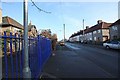
9
Thompson Road, Becontree
Thompson Road on the Becontree Estate.
Image: © Malc McDonald
Taken: 28 Aug 2017
0.24 miles
10
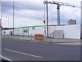
Construction Site on the A124 Wood Lane
At the junction with the A1083 Green Lane
Image: © Geographer
Taken: 4 May 2010
0.25 miles