IMAGES TAKEN NEAR TO
Gardiner Close, DAGENHAM, RM8 2XG
Introduction
This page details the photographs taken nearby to Gardiner Close, RM8 2XG by members of the Geograph project.
The Geograph project started in 2005 with the aim of publishing, organising and preserving representative images for every square kilometre of Great Britain, Ireland and the Isle of Man.

There are currently over 7.5m images from over14,400 individuals and you can help contribute to the project by visiting https://www.geograph.org.uk
Image Map
Images are licensed for reuse under creativecommons.org/licenses/by-sa/2.0
Notes
- Clicking on the map will re-center to the selected point.
- The higher the marker number, the further away the image location is from the centre of the postcode.
Image Listing (23 Images Found)
Images are licensed for reuse under creativecommons.org/licenses/by-sa/2.0
Image
Details
Distance
1
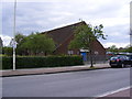
St. Elisabeth's Church Hall, Becontree
On the A124 Wood Lane
Image: © Geographer
Taken: 4 May 2010
0.14 miles
2
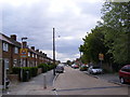
Hewitt Road, Becontree
At the junction with the A124 Wood Lane
Image: © Geographer
Taken: 4 May 2010
0.14 miles
3
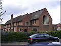
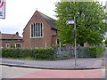
St. Elisabeth's Church, Becontree
On the A124 Wood Lane at the junction with Hewitt Road
Image: © Geographer
Taken: 4 May 2010
0.14 miles
4
St. Elisabeth's Church, Becontree
On the A124 Wood Lane at the junction with Hewitt Road
Image: © Geographer
Taken: 4 May 2010
0.14 miles
5
St. Elisabeth's Church, Becontree
On the A124 Wood Lane at the junction with Hewitt Road
Image: © Geographer
Taken: 4 May 2010
0.15 miles
6
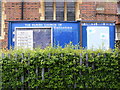
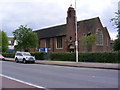
St. Elisabeth's Church Notice Board, Becontree
On the A124 Wood Lane
Image: © Geographer
Taken: 4 May 2010
0.15 miles
7
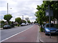
A124 Wood Lane, Becontree
Looking towards the junction with Bennett's Castle Lane near St Elisabeth's Church.
Image: © Geographer
Taken: 4 May 2010
0.16 miles
8
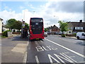
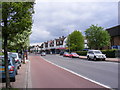
Bus stop and shelter on Longbridge Road, Dagenham
Looking east.
Image: © JThomas
Taken: 11 May 2019
0.16 miles
9
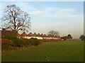
Wintry light in Parsloes Park
Parsloes Park lies on the site of Parsloes Manor, named after Hugh Passelewe, a 13th century owner. In 1619 the manor passed to the Fanshawe family, who owned it for 300 years until it was sold to the London County Council at the time of the First World War. The house which had fallen into disrepair was demolished in 1925 but the park was kept as open space for the residents of Becontree Estate, then under construction. It was opened as a public open space in 1935 to celebrate the official completion of the estate.
The lake is in the south-west corner of the park. This is in the northern part of the park looking towards the backs of the houses in Wren Avenue.
Image: © Marathon
Taken: 30 Nov 2016
0.16 miles
10
A124 Wood Lane, Becontree
Looking towards Becontree near the junction with Bushgrove Road & Hewitt Road and also near St. Elisabeth's Church
Image: © Geographer
Taken: 4 May 2010
0.16 miles