IMAGES TAKEN NEAR TO
Burnside Road, DAGENHAM, RM8 2JW
Introduction
This page details the photographs taken nearby to Burnside Road, RM8 2JW by members of the Geograph project.
The Geograph project started in 2005 with the aim of publishing, organising and preserving representative images for every square kilometre of Great Britain, Ireland and the Isle of Man.

There are currently over 7.5m images from over14,400 individuals and you can help contribute to the project by visiting https://www.geograph.org.uk
Image Map
Images are licensed for reuse under creativecommons.org/licenses/by-sa/2.0
Notes
- Clicking on the map will re-center to the selected point.
- The higher the marker number, the further away the image location is from the centre of the postcode.
Image Listing (36 Images Found)
Images are licensed for reuse under creativecommons.org/licenses/by-sa/2.0
Image
Details
Distance
2
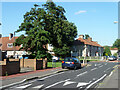
Trees at crossing of Winterbourne Road and Waldegrave Road, RM8
Image: © Robin Webster
Taken: 25 Jun 2011
0.08 miles
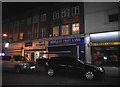
3
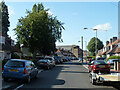
Waldegrave Road, Dagenham RM8
Looking north towards Green Lane.
Image: © Robin Webster
Taken: 25 Jun 2011
0.09 miles
4
St Thomas, Haydon Road, Becontree - East end
Image: © John Salmon
Taken: 19 Feb 2005
0.10 miles
6
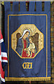
St Thomas, Haydon Road, Becontree - Banner
MU Banner
Image: © John Salmon
Taken: 19 Feb 2005
0.11 miles
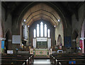
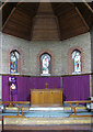
7
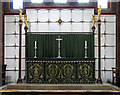
St Thomas, Haydon Road, Becontree - High altar
Image: © John Salmon
Taken: 19 Feb 2005
0.11 miles
8
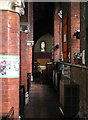
St Thomas, Haydon Road, Becontree - Passage aisle
Image: © John Salmon
Taken: 19 Feb 2005
0.11 miles
9
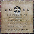
St Thomas, Haydon Road, Becontree - Foundation stone
Image: © John Salmon
Taken: 19 Feb 2005
0.11 miles
10
St Thomas, Haydon Road, Becontree - Chapel
Image: © John Salmon
Taken: 19 Feb 2005
0.11 miles