IMAGES TAKEN NEAR TO
Campus Avenue, DAGENHAM, RM8 2FN
Introduction
This page details the photographs taken nearby to Campus Avenue, RM8 2FN by members of the Geograph project.
The Geograph project started in 2005 with the aim of publishing, organising and preserving representative images for every square kilometre of Great Britain, Ireland and the Isle of Man.

There are currently over 7.5m images from over14,400 individuals and you can help contribute to the project by visiting https://www.geograph.org.uk
Image Map
Images are licensed for reuse under creativecommons.org/licenses/by-sa/2.0
Notes
- Clicking on the map will re-center to the selected point.
- The higher the marker number, the further away the image location is from the centre of the postcode.
Image Listing (23 Images Found)
Images are licensed for reuse under creativecommons.org/licenses/by-sa/2.0
Image
Details
Distance
1
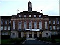
University of East London
This is the Barking Campus of the University of East London. UEL was formed in 1992 from the merger of West Ham Tech, South East Essex Tech and North East London Polytechnic. It has 18,000 students at this and two other major campuses in Stratford and new buildings in Docklands.
Image: © Glyn Baker
Taken: 16 Sep 2005
0.05 miles
5

St Thomas More RC Church, Barking, Essex
Image: © Peter Stack
Taken: 25 May 2009
0.16 miles
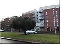
6
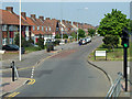
Becontree Avenue
The northbound side of this dual carriageway.
Image: © Robin Webster
Taken: 24 Apr 2011
0.16 miles
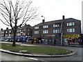
7
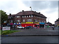
Post Office and shops on Becontree Avenue, Dagenham
Image: © JThomas
Taken: 11 May 2019
0.17 miles
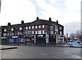
8
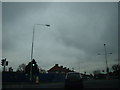
Where the Robin Hood PH once stood
This is the former location of the Robin Hood PH at the junction of Longbridge Road (crossing the photo), Lodge Avenue and Becontree Avenue. I can now confirm from driving past here earlier this year (2011), it is now a Lidl supermarket, which I was pleasantly surprised about!
Image: © Robert Lamb
Taken: 14 Dec 2008
0.17 miles
9
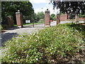
The northern entrance to Mayesbrook Park
Mayesbrook Park was first opened in 1934 during the growth of the Becontree Estate and was formed by enclosing land that was previously open countryside. The two lakes were created when gravel was extracted for use in building the Estate. The lakes are known locally as 'Matchstick Island' and more formally, if uninspiringly, as North Lake and South Lake.
The park was originally designed by the Landscape Architect Thomas Mawson but his plans were never fully realised as the Second World War intervened. Construction stopped and the park was used for temporary army accommodation.
In 2011 the park was significantly altered by widening the Mayes Brook, which followed the western edge of the park, and moving it to meander through the park.
This looks towards the northern entrance from inside the park. Waterside Close off Longbridge Road is beyond.
Image: © Marathon
Taken: 15 Jun 2016
0.18 miles
10
The northern entrance to Mayesbrook Park
Mayesbrook Park was first opened in 1934 during the growth of the Becontree Estate and was formed by enclosing land that was previously open countryside. The two lakes were created when gravel was extracted for use in building the Estate. The lakes are known locally as 'Matchstick Island' and more formally, if uninspiringly, as North Lake and South Lake.
The park was originally designed by the Landscape Architect Thomas Mawson but his plans were never fully realised as the Second World War intervened. Construction stopped and the park was used for temporary army accommodation.
In 2011 the park was significantly altered by widening the Mayes Brook, which followed the western edge of the park, and moving it to meander through the park.
This looks towards the northern entrance from Waterside Close off Longbridge Road.
Image: © Marathon
Taken: 15 Jun 2016
0.18 miles