IMAGES TAKEN NEAR TO
Academy Way, DAGENHAM, RM8 2FB
Introduction
This page details the photographs taken nearby to Academy Way, RM8 2FB by members of the Geograph project.
The Geograph project started in 2005 with the aim of publishing, organising and preserving representative images for every square kilometre of Great Britain, Ireland and the Isle of Man.

There are currently over 7.5m images from over14,400 individuals and you can help contribute to the project by visiting https://www.geograph.org.uk
Image Map
Images are licensed for reuse under creativecommons.org/licenses/by-sa/2.0
Notes
- Clicking on the map will re-center to the selected point.
- The higher the marker number, the further away the image location is from the centre of the postcode.
Image Listing (10 Images Found)
Images are licensed for reuse under creativecommons.org/licenses/by-sa/2.0
Image
Details
Distance
1
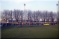
Barking Football Club, Mayesbrook Park
Barking 1 Oxford United 0, FA Cup 1st round
Image: © Steve Daniels
Taken: 24 Nov 1979
0.13 miles
4
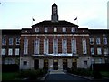
University of East London
This is the Barking Campus of the University of East London. UEL was formed in 1992 from the merger of West Ham Tech, South East Essex Tech and North East London Polytechnic. It has 18,000 students at this and two other major campuses in Stratford and new buildings in Docklands.
Image: © Glyn Baker
Taken: 16 Sep 2005
0.20 miles
5
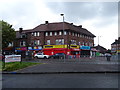
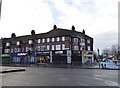
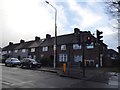
Post Office and shops on Becontree Avenue, Dagenham
Image: © JThomas
Taken: 11 May 2019
0.21 miles
6
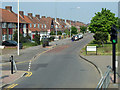
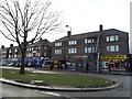
Becontree Avenue
The northbound side of this dual carriageway.
Image: © Robin Webster
Taken: 24 Apr 2011
0.22 miles
7
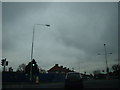
Where the Robin Hood PH once stood
This is the former location of the Robin Hood PH at the junction of Longbridge Road (crossing the photo), Lodge Avenue and Becontree Avenue. I can now confirm from driving past here earlier this year (2011), it is now a Lidl supermarket, which I was pleasantly surprised about!
Image: © Robert Lamb
Taken: 14 Dec 2008
0.22 miles
8
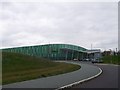
The Sporthouse, Mayesbrook Park
Sporthouse, in Mayesbrook Park, Lodge Avenue, is one of only three new training venues commissioned by Olympic chiefs for competitors to use during the 2012 Olympic Games.
It was officially launched in March 2012 by sports luminaries including rowing champion Sir Steve Redgrave and International Olympic Committee member Sam Ramsamy.
Now used as a sports hall, which has space for up to 3,000 spectators, the centre also includes two gyms with 300 exercise stations.
Image: © David Anstiss
Taken: 31 Mar 2013
0.23 miles
10
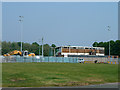
Redevelopment in Mayesbrook Park
Work has started on a large indoor sports building. The building seen here, partly a stand for the athletics field to the north, was to be demolished.
Image: © Robin Webster
Taken: 24 Apr 2011
0.24 miles