IMAGES TAKEN NEAR TO
Mayfield Road, DAGENHAM, RM8 1XT
Introduction
This page details the photographs taken nearby to Mayfield Road, RM8 1XT by members of the Geograph project.
The Geograph project started in 2005 with the aim of publishing, organising and preserving representative images for every square kilometre of Great Britain, Ireland and the Isle of Man.

There are currently over 7.5m images from over14,400 individuals and you can help contribute to the project by visiting https://www.geograph.org.uk
Image Map (Loading...)


Getting Data...Please wait
Leaflet Map data © OpenStreetMap
Images are licensed for reuse under creativecommons.org/licenses/by-sa/2.0
Notes
- Clicking on the map will re-center to the selected point.
- The higher the marker number, the further away the image location is from the centre of the postcode.
Image Listing (18 Images Found)
Images are licensed for reuse under creativecommons.org/licenses/by-sa/2.0
Image
Details
Distance
2
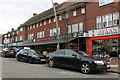
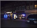
Fountain Gate Tabernacle, Green Lane
Run by the Church of the Pentecost UK. Formerly a cinema - the Odeon. The auditorium runs at right angles behind the shops to the right.
Image: © Robin Webster
Taken: 25 Jun 2011
0.06 miles
3
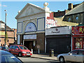
Fountain Gate Tabernacle
Run by the Church of the Pentecost UK. Formerly a cinema - the Odeon. The entrance is on Green Lane ahead, in a less utilitarian style.
Image: © Robin Webster
Taken: 25 Jun 2011
0.08 miles
6
The dirty corner of the lake
All of the debris in the Goodmayes Park lake has ended up here.
Image: © Robin Webster
Taken: 25 Jun 2011
0.10 miles
7
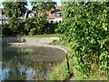
The dirty corner of the lake
All of the debris in the Goodmayes Park lake has ended up here.
Image: © Robin Webster
Taken: 25 Jun 2011
0.10 miles
9
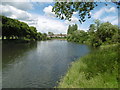
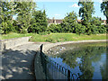
The lake in Goodmayes Park
Goodmayes Park was laid out in 1901 to provide a green 'lung' for the new Mayfield Estate, built by developer A Cameron Corbett, who donated land for the park to the Urban District Council. The area grew up following the arrival of the railway in 1901 and is named after Goodmayes Farm, which once stood on what is now the park. The park was opened to the public in 1905.
Goodmayes Park is divided by Mayesbrook Road into two compartments, that in the north having a lake formed by damming the Mayes Brook. The lake is divided by a footbridge. This is the view from the footbridge looking to the northern part of the lake.
A fuller description of the park can be seen at http://www.londongardensonline.org.uk/gardens-online-record.asp?ID=RED015
Image: © Marathon
Taken: 15 Jun 2016
0.15 miles
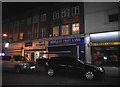
10
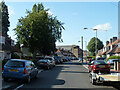
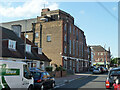
Waldegrave Road, Dagenham RM8
Looking north towards Green Lane.
Image: © Robin Webster
Taken: 25 Jun 2011
0.16 miles