IMAGES TAKEN NEAR TO
Jade Close, DAGENHAM, RM8 1XG
Introduction
This page details the photographs taken nearby to Jade Close, RM8 1XG by members of the Geograph project.
The Geograph project started in 2005 with the aim of publishing, organising and preserving representative images for every square kilometre of Great Britain, Ireland and the Isle of Man.

There are currently over 7.5m images from over14,400 individuals and you can help contribute to the project by visiting https://www.geograph.org.uk
Image Map
Images are licensed for reuse under creativecommons.org/licenses/by-sa/2.0
Notes
- Clicking on the map will re-center to the selected point.
- The higher the marker number, the further away the image location is from the centre of the postcode.
Image Listing (10 Images Found)
Images are licensed for reuse under creativecommons.org/licenses/by-sa/2.0
Image
Details
Distance
1
Goodmayes footbridge
The footbridge connects two schools on either side of the railway line between Goodmayes and Chadwell Heath Stations.
Image: © Clint Mann
Taken: 3 May 2016
0.20 miles
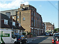
3
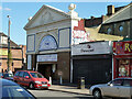
Fountain Gate Tabernacle, Green Lane
Run by the Church of the Pentecost UK. Formerly a cinema - the Odeon. The auditorium runs at right angles behind the shops to the right.
Image: © Robin Webster
Taken: 25 Jun 2011
0.21 miles
7
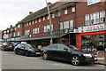
Fountain Gate Tabernacle
Run by the Church of the Pentecost UK. Formerly a cinema - the Odeon. The entrance is on Green Lane ahead, in a less utilitarian style.
Image: © Robin Webster
Taken: 25 Jun 2011
0.23 miles
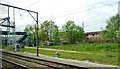
8
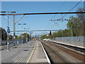
Chadwell Heath station
The line through here was opened on 20th June 1839 by the Eastern Counties Railway, as the Mile End (temporary terminus) to Romford section of what was to become the Great Eastern Main Line. The London terminus was moved in July 1840 to Shoreditch (later renamed Bishopsgate), and at the eastern end the line was extended out to Brentwood in the same year. Colchester was reached by 1843. Liverpool Street opened in stages from February 1874. The line was quadrupled to Ilford in 1895 and in 1899 out to Seven Kings. In 1902 the quadruple track was extended from Seven Kings through Chadwell Heath to Romford.
Chadwell Heath station was opened on 11th January 1864, and is built on the site of Wangey House, one of Dagenham's oldest buildings dating back to 1250. Wangey House was partly demolished when the Eastern Counties Railway built the line in the 1830s.
In this photograph the original lines, now the slow lines are to the right while the fast lines dating from 1902 are to the left beyond the railings. The next station in this direction is Goodmayes.
Image: © Marathon
Taken: 4 May 2016
0.23 miles