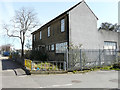
IMAGES TAKEN NEAR TO
Freshwater Road, DAGENHAM, RM8 1RX
Introduction
This page details the photographs taken nearby to Freshwater Road, RM8 1RX by members of the Geograph project.
The Geograph project started in 2005 with the aim of publishing, organising and preserving representative images for every square kilometre of Great Britain, Ireland and the Isle of Man.

There are currently over 7.5m images from over14,400 individuals and you can help contribute to the project by visiting https://www.geograph.org.uk
Image Map
Images are licensed for reuse under creativecommons.org/licenses/by-sa/2.0
Notes
- Clicking on the map will re-center to the selected point.
- The higher the marker number, the further away the image location is from the centre of the postcode.
Image Listing (13 Images Found)
Images are licensed for reuse under creativecommons.org/licenses/by-sa/2.0
Image
Details
Distance
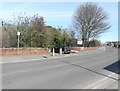
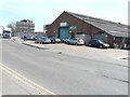
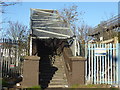
2
Industrial Unit, Freshwater Road, Chadwell Heath
On the other side of the road to the east of the Nicholls and Clarke building.
Image: © Christine Matthews
Taken: 28 Jan 2012
0.10 miles
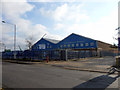
3
Locks Building, Freshwater Road, Chadwell Heath
Just east of the Nicholls and Clarke building on the other side of the road.
Image: © Christine Matthews
Taken: 28 Jan 2012
0.10 miles
4
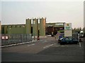
Dairy Crest Chadwell Heath
Not exactly the picture that comes to mind when you say the word “dairy” but that is what this factory is, it produces “liquid milk products”.
Image: © Glyn Baker
Taken: 22 Sep 2005
0.11 miles
5
M?ller Dairies, Selinas Lane
Once the home of Dairy Crest Ltd, Chadwell Heath Depot, but now disused.
Image: © John Baker
Taken: 5 Apr 2018
0.12 miles
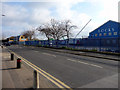
7
Freshwater Road, Chadwell Heath
Looking from the Nicholls and Clarke car park.
Image: © Christine Matthews
Taken: 28 Jan 2012
0.14 miles
8
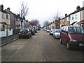
Chadwell Heath: Heath Road
Heath Road runs parallel to the railway which is to the left in this view taken from the very eastern end of the road.
Image: © Nigel Cox
Taken: 30 Nov 2007
0.15 miles
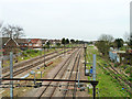
9
Foot crossing over the railway
The line through here was opened on 20th June 1839 by the Eastern Counties Railway, as the Mile End (temporary terminus) to Romford section of what was to become the Great Eastern Main Line. The London terminus was moved in July 1840 to Shoreditch (later renamed Bishopsgate), and at the eastern end the line was extended out to Brentwood in the same year. Colchester was reached by 1843. Liverpool Street opened in stages from February 1874. The line was quadrupled to Ilford in 1895 and in 1899 out to Seven Kings. In 1902 the quadruple track was extended from Seven Kings through Chadwell Heath to Romford.
This footbridge is on a path from Selinas Lane to Heath Road. The next station to the left is Chadwell Heath and to the right is Romford.
Image: © Marathon
Taken: 29 Dec 2016
0.17 miles
10
Railway east of Chadwell Heath
Local lines on the left (are they still called 'Electric'?), Main lines on the right, with extreme right a disused freight line formerly an eastern approach to the long gone Goodmayes Yard.
Image: © Robin Webster
Taken: 2 Apr 2011
0.19 miles