IMAGES TAKEN NEAR TO
Norfolk Road, ROMFORD, RM7 9DL
Introduction
This page details the photographs taken nearby to Norfolk Road, RM7 9DL by members of the Geograph project.
The Geograph project started in 2005 with the aim of publishing, organising and preserving representative images for every square kilometre of Great Britain, Ireland and the Isle of Man.

There are currently over 7.5m images from over14,400 individuals and you can help contribute to the project by visiting https://www.geograph.org.uk
Image Map
Images are licensed for reuse under creativecommons.org/licenses/by-sa/2.0
Notes
- Clicking on the map will re-center to the selected point.
- The higher the marker number, the further away the image location is from the centre of the postcode.
Image Listing (17 Images Found)
Images are licensed for reuse under creativecommons.org/licenses/by-sa/2.0
Image
Details
Distance
1
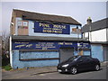
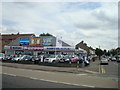
Pine House factory showroom, Norfolk Gardens, Romford
Image: © PAUL FARMER
Taken: 2 Apr 2011
0.06 miles
2
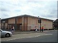
Former Lookers Chrysler car dealership
Image: © Stacey Harris
Taken: 23 Jul 2010
0.07 miles
3
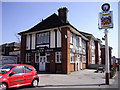
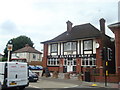
The Slaters Arms Public House, London Road, Romford
Image: © PAUL FARMER
Taken: 17 Apr 2010
0.09 miles
6
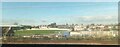
Coral Romford Greyhound Stadium, from the railway
Image: © Christopher Hilton
Taken: 18 Nov 2022
0.11 miles
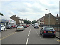
7
The Slaters Arms public house, London Road, Romford
Image: © Stacey Harris
Taken: 23 Jul 2010
0.12 miles
8
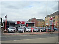
Tony Le Voi Vauxhall car dealership, Romford
Image: © Stacey Harris
Taken: 23 Jul 2010
0.12 miles
10
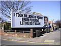
Conservative Party Election poster, London Road, Romford
This advertising hoarding is at the corner of London Road and Esher Avenue.
Image: © PAUL FARMER
Taken: 17 Apr 2010
0.15 miles