IMAGES TAKEN NEAR TO
White Hart Lane, ROMFORD, RM7 8JS
Introduction
This page details the photographs taken nearby to White Hart Lane, RM7 8JS by members of the Geograph project.
The Geograph project started in 2005 with the aim of publishing, organising and preserving representative images for every square kilometre of Great Britain, Ireland and the Isle of Man.

There are currently over 7.5m images from over14,400 individuals and you can help contribute to the project by visiting https://www.geograph.org.uk
Image Map
Images are licensed for reuse under creativecommons.org/licenses/by-sa/2.0
Notes
- Clicking on the map will re-center to the selected point.
- The higher the marker number, the further away the image location is from the centre of the postcode.
Image Listing (15 Images Found)
Images are licensed for reuse under creativecommons.org/licenses/by-sa/2.0
Image
Details
Distance
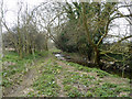
5
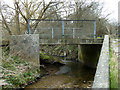
Bridge over River Rom
A public footpath crosses, but the bridge is sized for vehicles, as are ramps descending to the river banks in each direction, on opposite sides of the water. There is little sign of vehicle use, particularly for the ramps.
Image: © Robin Webster
Taken: 8 Apr 2013
0.12 miles
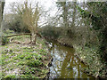
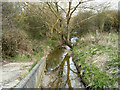
6
Bridge over River Rom
A public footpath crosses.
Image: © Robin Webster
Taken: 8 Apr 2013
0.12 miles
8
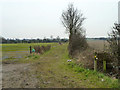
Permissive footpath, Collier Row
The sign, although apparently marked with the usual public footpath arrows, also says "Please keep to the permissive route". There is no mapped public route heading in that direction from here. The path acts as a link between two public paths.
Image: © Robin Webster
Taken: 8 Apr 2013
0.20 miles
9
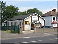
Collier Row Gospel Hall
The hall is on the north side of Collier Row Road and has a website here http://www.crgh.org.uk/home.htm
(From a Geograph point of view, the front of the hall seen here is clearly in this grid square according to the OS 1:10,000 scale maps, and not in Image as shown on the OS 1:50,000 scale maps.)
Image: © Nigel Cox
Taken: 27 Jul 2008
0.21 miles
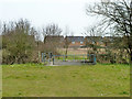
10
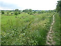
Footpath to Marks Gate
The footpath runs cross open land in the valley of the River Rom between White Hart Lane and Marks Gate. Here Crownfield School is on the right, just after leaving White Hart Lane.
Image: © Marathon
Taken: 31 May 2017
0.21 miles