IMAGES TAKEN NEAR TO
Marlborough Road, ROMFORD, RM7 8AS
Introduction
This page details the photographs taken nearby to Marlborough Road, RM7 8AS by members of the Geograph project.
The Geograph project started in 2005 with the aim of publishing, organising and preserving representative images for every square kilometre of Great Britain, Ireland and the Isle of Man.

There are currently over 7.5m images from over14,400 individuals and you can help contribute to the project by visiting https://www.geograph.org.uk
Image Map
Images are licensed for reuse under creativecommons.org/licenses/by-sa/2.0
Notes
- Clicking on the map will re-center to the selected point.
- The higher the marker number, the further away the image location is from the centre of the postcode.
Image Listing (4 Images Found)
Images are licensed for reuse under creativecommons.org/licenses/by-sa/2.0
Image
Details
Distance
1
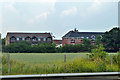
Housing north of the A12
In Blandford and Calgary Courts, infilling behind older houses on Marlborough Road.
Image: © Robin Webster
Taken: 11 Jun 2011
0.18 miles
2
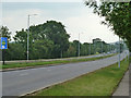
A12 heading east
A puzzling low emission sign on the left, for traffic heading away from central London. Just a reminder?
Image: © Robin Webster
Taken: 11 Jun 2011
0.23 miles
3
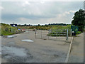
Entrance to landfill site
A turning off the A12 on the right.
Image: © Robin Webster
Taken: 11 Jun 2011
0.24 miles
4
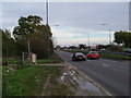
Footpath to Warren Farm
The footpath to the left leads to Warren Farm Image and Whalebone Lane North. The road is the A12 looking eastbound towards Romford.
Image: © Glyn Baker
Taken: 2 Dec 2005
0.25 miles