IMAGES TAKEN NEAR TO
Beech Street, ROMFORD, RM7 7LA
Introduction
This page details the photographs taken nearby to Beech Street, RM7 7LA by members of the Geograph project.
The Geograph project started in 2005 with the aim of publishing, organising and preserving representative images for every square kilometre of Great Britain, Ireland and the Isle of Man.

There are currently over 7.5m images from over14,400 individuals and you can help contribute to the project by visiting https://www.geograph.org.uk
Image Map
Images are licensed for reuse under creativecommons.org/licenses/by-sa/2.0
Notes
- Clicking on the map will re-center to the selected point.
- The higher the marker number, the further away the image location is from the centre of the postcode.
Image Listing (36 Images Found)
Images are licensed for reuse under creativecommons.org/licenses/by-sa/2.0
Image
Details
Distance
1
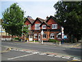
Romford: Mawney Arms
The Mawney Arms is located on Mawney Road at the junction with Willow Street.
Image: © Nigel Cox
Taken: 27 Jul 2008
0.13 miles
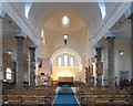
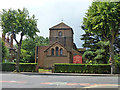
3
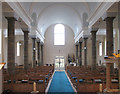
St John the Divine, Mawney Road, Romford - West end
Image: © John Salmon
Taken: 2 Mar 2005
0.15 miles
4
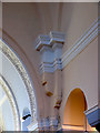
St John the Divine, Mawney Road, Romford - Architectural feature
Image: © John Salmon
Taken: 2 Mar 2005
0.15 miles
5
St John the Divine, Mawney Road, Romford - East end
Image: © John Salmon
Taken: 2 Mar 2005
0.15 miles
6
St John the Divine, Mawney Road, Romford
Image: © John Salmon
Taken: 15 Feb 2005
0.15 miles
7
St John the Divine, Mawney Road, Romford
Image: © John Salmon
Taken: 2 Mar 2005
0.16 miles
8
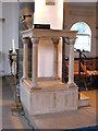
St John the Divine, Mawney Road, Romford - Pulpit
Image: © John Salmon
Taken: 2 Mar 2005
0.16 miles
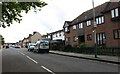
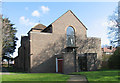
9

Junction of Popular Street and Mawney Road
Image: © PAUL FARMER
Taken: 19 Dec 2009
0.16 miles
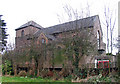
10
Church of St John the Divine, Romford
On Mawney Road, with its car park and church hall accessed from Pretoria Road, behind.
Image: © Robin Webster
Taken: 11 Jun 2011
0.16 miles