IMAGES TAKEN NEAR TO
Brooklands Close, ROMFORD, RM7 7ES
Introduction
This page details the photographs taken nearby to Brooklands Close, RM7 7ES by members of the Geograph project.
The Geograph project started in 2005 with the aim of publishing, organising and preserving representative images for every square kilometre of Great Britain, Ireland and the Isle of Man.

There are currently over 7.5m images from over14,400 individuals and you can help contribute to the project by visiting https://www.geograph.org.uk
Image Map
Images are licensed for reuse under creativecommons.org/licenses/by-sa/2.0
Notes
- Clicking on the map will re-center to the selected point.
- The higher the marker number, the further away the image location is from the centre of the postcode.
Image Listing (49 Images Found)
Images are licensed for reuse under creativecommons.org/licenses/by-sa/2.0
Image
Details
Distance
1
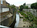
River Rom from Como Street bridge
There is provision for a considerable increase in flow, which can occur very quickly with the rapid run-off from urban areas.
Image: © Robin Webster
Taken: 11 Jun 2011
0.03 miles
2
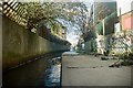
The River Rom
Public access to this part of the Rom is difficult, as much of it was culverted and fenced off during town redevelopment in the 1960s. However, Havering Council have recently announced plans to open up the river.
Image: © Richard Winch
Taken: 17 Feb 2018
0.04 miles
3
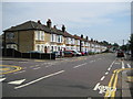
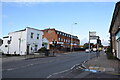
Romford: Como Street
This was an attempt to try to re-create a Francis Frith image of an ordinary street scene from 100 years ago. The Frith image can be seen here http://www.francisfrith.com/search/england/essex/romford/photos/romford_59816.htm I did not quite get the angle right but the houses are recognisably the same. The identical houses on the right side of the street visible in the Frith version still exist by the way. This photograph was taken at the junction of Como Street with Brooklands Road to the left and Olive Street to the right. The houses must have been fairly new in 1908 as the 1897 Edition of the Ordnance Survey 6" to the mile map does not show them, although Como Street itself is shown.
Spot the differences! The furthest three in the first block of six have evidently lost their pitched roofs over the bay windows at some stage, and indeed this seems to have happened to most of the houses in the street.
Image: © Nigel Cox
Taken: 27 Jul 2008
0.04 miles
4
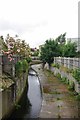
The River Rom
Looking upstream from Como Street
Image: © Glyn Baker
Taken: 3 Jul 2012
0.05 miles
5
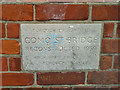
Stone on Como Street Bridge
Over the River Rom.
Image: © Robin Webster
Taken: 11 Jun 2011
0.05 miles
7
North Street, Romford
Taken from the end of Ingrave Road. A significant spot for me as many years ago my father worked for Bettaware Brushes - which occupied the site where the brick building ahead now stands.
Image: © Trevor Harris
Taken: 22 Oct 2020
0.08 miles
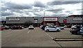
9
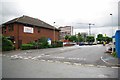
Como Street Car park
One of a number of single level Car Parks dotted around the Romford Ring Road.
Image: © Glyn Baker
Taken: 3 Jul 2012
0.10 miles
10
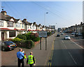
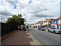
Welcome to Romford
A historic market town.
Looking along North Street.
West Ham United hi-viz coat in the foreground.
Image: © Des Blenkinsopp
Taken: 8 Apr 2015
0.10 miles