IMAGES TAKEN NEAR TO
Horace Avenue, ROMFORD, RM7 0UP
Introduction
This page details the photographs taken nearby to Horace Avenue, RM7 0UP by members of the Geograph project.
The Geograph project started in 2005 with the aim of publishing, organising and preserving representative images for every square kilometre of Great Britain, Ireland and the Isle of Man.

There are currently over 7.5m images from over14,400 individuals and you can help contribute to the project by visiting https://www.geograph.org.uk
Image Map
Images are licensed for reuse under creativecommons.org/licenses/by-sa/2.0
Notes
- Clicking on the map will re-center to the selected point.
- The higher the marker number, the further away the image location is from the centre of the postcode.
Image Listing (22 Images Found)
Images are licensed for reuse under creativecommons.org/licenses/by-sa/2.0
Image
Details
Distance
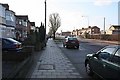
2

Leonard Avenue bus stop, Rush Green Road
Served by routes 5, 103, 128, 175 and N15.
Image: © Robin Webster
Taken: 18 Sep 2011
0.07 miles
3
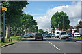
Speed camera on A124 Rush Green Road
Heading west.
Image: © Robin Webster
Taken: 18 Sep 2011
0.11 miles
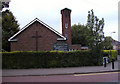
4
St Augustine of Canterbury, Rush Green Road, Rush Green - East end
Image: © John Salmon
Taken: 20 May 2010
0.11 miles
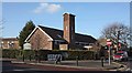
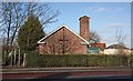
7
St Augustine of Canterbury Church Romford Essex
Image: © Peter Stack
Taken: 25 May 2009
0.12 miles
8
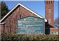
St Augustine, Rush Green Road - Notice board
Image: © John Salmon
Taken: 26 Jan 2009
0.12 miles
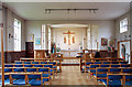
9
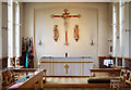
St Augustine of Canterbury, Rush Green Road, Rush Green - Chancel
Image: © John Salmon
Taken: 20 May 2010
0.13 miles
10
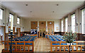
St Augustine of Canterbury, Rush Green Road, Rush Green - West end
Image: © John Salmon
Taken: 20 May 2010
0.13 miles