IMAGES TAKEN NEAR TO
Dagenham Road, ROMFORD, RM7 0TR
Introduction
This page details the photographs taken nearby to Dagenham Road, RM7 0TR by members of the Geograph project.
The Geograph project started in 2005 with the aim of publishing, organising and preserving representative images for every square kilometre of Great Britain, Ireland and the Isle of Man.

There are currently over 7.5m images from over14,400 individuals and you can help contribute to the project by visiting https://www.geograph.org.uk
Image Map
Images are licensed for reuse under creativecommons.org/licenses/by-sa/2.0
Notes
- Clicking on the map will re-center to the selected point.
- The higher the marker number, the further away the image location is from the centre of the postcode.
Image Listing (7 Images Found)
Images are licensed for reuse under creativecommons.org/licenses/by-sa/2.0
Image
Details
Distance
1
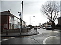
Lincoln Avenue at the junction of Dagenham Road
Image: © David Howard
Taken: 5 Mar 2017
0.01 miles
2
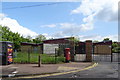
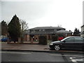
Rush Green Medical Centre
On Dagenham Road, Rush Green.
Showing position of Postbox No. RM7 300.
See Image] for postbox.
Image: © JThomas
Taken: 11 May 2019
0.04 miles
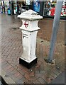
3
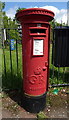
George V postbox on Dagenham Road, Rush Green
Postbox No. RM7 300.
See Image] for context.
Image: © JThomas
Taken: 11 May 2019
0.04 miles

7
Coal duty boundary marker, west side of Dagenham Road
Iron boundary marker. 4826VIC CAP42
Milestone Society National ID: EX_CTROM01bm
Image: © Paul Jones
Taken: 12 Oct 2020
0.24 miles