IMAGES TAKEN NEAR TO
Meadow Road, ROMFORD, RM7 0LR
Introduction
This page details the photographs taken nearby to Meadow Road, RM7 0LR by members of the Geograph project.
The Geograph project started in 2005 with the aim of publishing, organising and preserving representative images for every square kilometre of Great Britain, Ireland and the Isle of Man.

There are currently over 7.5m images from over14,400 individuals and you can help contribute to the project by visiting https://www.geograph.org.uk
Image Map
Images are licensed for reuse under creativecommons.org/licenses/by-sa/2.0
Notes
- Clicking on the map will re-center to the selected point.
- The higher the marker number, the further away the image location is from the centre of the postcode.
Image Listing (17 Images Found)
Images are licensed for reuse under creativecommons.org/licenses/by-sa/2.0
Image
Details
Distance
1
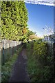
Footpath 153
This is the path from Crow Lane to Image
Image: © Glyn Baker
Taken: 2 Dec 2012
0.12 miles
2
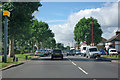
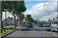
Speed camera on A124 Rush Green Road
Heading west.
Image: © Robin Webster
Taken: 18 Sep 2011
0.14 miles
3
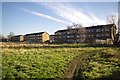
Rush Green Gardens
The rear of the Rush Green Gardens flats from Image
Image: © Glyn Baker
Taken: 2 Dec 2012
0.14 miles
4
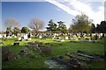
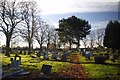
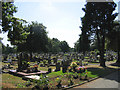
Romford Cemetery Crow Lane
The frost still lingers where the sun doesn't shine. A winter's afternoon in Romford Cemetery.
Image: © Glyn Baker
Taken: 2 Dec 2012
0.14 miles
5
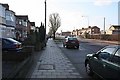
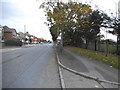
A124 Rush Green Road
Heading west with Clayton Road bus stop on the left.
Image: © Robin Webster
Taken: 18 Sep 2011
0.15 miles
6
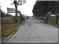
The entrance to Romford and Gidea Park RFC
Image: © David Howard
Taken: 21 Oct 2017
0.18 miles
10
Oldchurch Cemetery, Oldchurch Road, Romford, Essex
Image: © John Winfield
Taken: 12 Jul 2005
0.21 miles