IMAGES TAKEN NEAR TO
Goldsmith Avenue, ROMFORD, RM7 0EX
Introduction
This page details the photographs taken nearby to Goldsmith Avenue, RM7 0EX by members of the Geograph project.
The Geograph project started in 2005 with the aim of publishing, organising and preserving representative images for every square kilometre of Great Britain, Ireland and the Isle of Man.

There are currently over 7.5m images from over14,400 individuals and you can help contribute to the project by visiting https://www.geograph.org.uk
Image Map
Images are licensed for reuse under creativecommons.org/licenses/by-sa/2.0
Notes
- Clicking on the map will re-center to the selected point.
- The higher the marker number, the further away the image location is from the centre of the postcode.
Image Listing (10 Images Found)
Images are licensed for reuse under creativecommons.org/licenses/by-sa/2.0
Image
Details
Distance
1
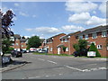
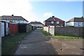
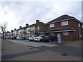
Braithwaite Avenue, near Romford
Braithwaite Avenue is a residential cul-de-sac near Romford in East London's outer suburbs.
Image: © Malc McDonald
Taken: 25 May 2013
0.07 miles
2
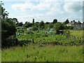
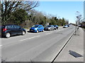
Temple Allotments, Dagenham
Accessed from Fambridge Road. There is a lot more hidden by the tree on the left.
Image: © Robin Webster
Taken: 25 Jun 2011
0.08 miles
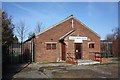
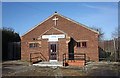
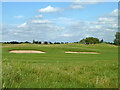
5
Track to and from Hartley Brook Church, Rosslyn Avenue
Image: © John Salmon
Taken: 26 Jan 2009
0.12 miles
8
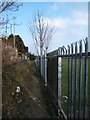
Footpath to Crow Lane
This is footpath #12 running from Becontree Heath to Crow Lane in Rush Green. Note the enterprising yobs in the area have cut the fence to gain access to the school playing fields!
Image: © Glyn Baker
Taken: 18 Mar 2006
0.18 miles
10
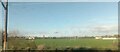
Westland's Playing Fields, from the railway
Image: © Christopher Hilton
Taken: 18 Nov 2022
0.22 miles