IMAGES TAKEN NEAR TO
East Road, ROMFORD, RM6 6YS
Introduction
This page details the photographs taken nearby to East Road, RM6 6YS by members of the Geograph project.
The Geograph project started in 2005 with the aim of publishing, organising and preserving representative images for every square kilometre of Great Britain, Ireland and the Isle of Man.

There are currently over 7.5m images from over14,400 individuals and you can help contribute to the project by visiting https://www.geograph.org.uk
Image Map
Images are licensed for reuse under creativecommons.org/licenses/by-sa/2.0
Notes
- Clicking on the map will re-center to the selected point.
- The higher the marker number, the further away the image location is from the centre of the postcode.
Image Listing (6 Images Found)
Images are licensed for reuse under creativecommons.org/licenses/by-sa/2.0
Image
Details
Distance
1

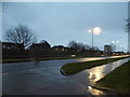
Traffic Jam on Whalebone Lane
This shot was taken near Adelaide Gardens looking South along Whalebone Lane North. I wonder if cyclists are any safer with the addition of a green road surface and a cyclepath sign?
Image: © Glyn Baker
Taken: 2 Dec 2005
0.19 miles
3
Green verge on Eastern Avenue, Chadwell Heath
Image: © David Howard
Taken: 5 Mar 2017
0.21 miles
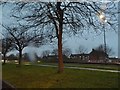
4
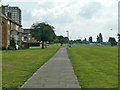
A monotonous path
The long green (also monotonous) is a buffer between the A12 on the left and flats south of Padnall Road on the right.
Image: © Robin Webster
Taken: 11 Jun 2011
0.23 miles
5
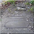
Old Boundary Marker by the A1112, Whalebone Lane North, Dagenham parish
Municipal Boundary Marker by the A1112, in parish of Dagenham (Barking And Dagenham District), Whalebone Lane North, immediately north of red brick pier at north end of the Warren School fence.
N.B. The location of this photo is correct, and agrees with the O.S. maps back to 1864, but the grid ref does not agree with the Historic England listing.
Grade II listed. List Entry Number: 1064420
https://historicengland.org.uk/listing/the-list/list-entry/1064420
Surveyed
Milestone Society National ID: EX_HAVE07pb
Image: © Milestone Society
Taken: Unknown
0.23 miles
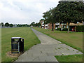
6
Path parallel with A12
Looking towards the A12/A1112 (Whalebone Lane) junction.
Image: © Robin Webster
Taken: 11 Jun 2011
0.24 miles