IMAGES TAKEN NEAR TO
Whalebone Lane North, ROMFORD, RM6 6RB
Introduction
This page details the photographs taken nearby to Whalebone Lane North, RM6 6RB by members of the Geograph project.
The Geograph project started in 2005 with the aim of publishing, organising and preserving representative images for every square kilometre of Great Britain, Ireland and the Isle of Man.

There are currently over 7.5m images from over14,400 individuals and you can help contribute to the project by visiting https://www.geograph.org.uk
Image Map
Images are licensed for reuse under creativecommons.org/licenses/by-sa/2.0
Notes
- Clicking on the map will re-center to the selected point.
- The higher the marker number, the further away the image location is from the centre of the postcode.
Image Listing (12 Images Found)
Images are licensed for reuse under creativecommons.org/licenses/by-sa/2.0
Image
Details
Distance
1
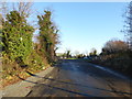
Warren Farm
This is looking from Whalebone North into the entrance leading to Warren Farm. From the aerial photograph it is clear there are no animals or crops on Warren Farm which seems to be mostly given over to sand quarrying.
Image: © Marathon
Taken: 29 Dec 2016
0.03 miles
3
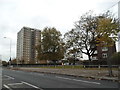
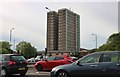
High View House
Overlooking the A12/A1112 Whalebone Lane junction.
Image: © Robin Webster
Taken: 11 Jun 2011
0.06 miles
4
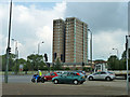
Highview House, Chadwell Heath
Opposite the Moby Dick pub on a cul-de-sac off Rose Lane called Hatch Grove is Highview House - quite an appropriate name if you live on the upper floors! As you can see, there is also a pleasant green in the vicinity, which is a refreshing change to see around a London towerblock. A little way back along the Eastern Avenue is also a large pond on the green, which also adds to the rural scenery - there is countryside just past the Moby Dick on both sides of the Eastern Avenue, showing just how rural this part of London is.
Image: © Robert Lamb
Taken: 7 Dec 2008
0.06 miles
5
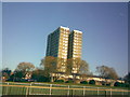
High View House, Chadwell Heath
From Eastern Avenue
Image: © David Howard
Taken: 25 May 2019
0.07 miles
6
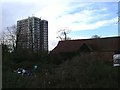
Old and New
This barn at Warren Farm off Whalebone Lane North has its own (rather overgrown) moat, it has been around for more than a week or two! Highview House in the background is somewhat younger
Image: © Glyn Baker
Taken: 2 Dec 2005
0.07 miles
7
Eastern Avenue at the junction of Whalebone Lane North
Image: © David Howard
Taken: 15 May 2012
0.13 miles

9
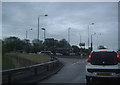
Eastern Avenue West (A12)
It may have looked quiet but the traffic lights at Whalebone North, behind where I was standing, had not yet changed. This stretch of the A12 is heading into the Green Belt, hence no pavement alongside the road.
Image: © Marathon
Taken: 29 Dec 2016
0.13 miles
10
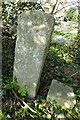
Old Boundary Markers on the A1112 Whalebone Lane North
Municipal Boundary Markers called the Marks Stones in a hedge on the east side of the A1112 Whalebone Lane North. In the former Dagenham parish, now the London Borough of Barking and Dagenham. EX_HAVE04pb on the left is inscribed MARKS / STONE and EX_HAVE05pb on the right is inscribed MARKS / STONE / SEPT / 1642. Grade II Listed details https://historicengland.org.uk/listing/the-list/list-entry/1079887.
Milestone Society National ID: EX_HAVE04pb on the left and EX_HAVE05pb on the right
Image: © M Bardell
Taken: 8 Apr 2017
0.15 miles