IMAGES TAKEN NEAR TO
Wadeville Avenue, ROMFORD, RM6 6EX
Introduction
This page details the photographs taken nearby to Wadeville Avenue, RM6 6EX by members of the Geograph project.
The Geograph project started in 2005 with the aim of publishing, organising and preserving representative images for every square kilometre of Great Britain, Ireland and the Isle of Man.

There are currently over 7.5m images from over14,400 individuals and you can help contribute to the project by visiting https://www.geograph.org.uk
Image Map (Loading...)


Getting Data...Please wait
Leaflet Map data © OpenStreetMap
Images are licensed for reuse under creativecommons.org/licenses/by-sa/2.0
Notes
- Clicking on the map will re-center to the selected point.
- The higher the marker number, the further away the image location is from the centre of the postcode.
Image Listing (41 Images Found)
Images are licensed for reuse under creativecommons.org/licenses/by-sa/2.0
Image
Details
Distance
1
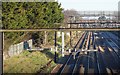
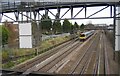
Looking towards Romford from a footbridge
The line through here was opened on 20th June 1839 by the Eastern Counties Railway, as the Mile End (temporary terminus) to Romford section of what was to become the Great Eastern Main Line. The London terminus was moved in July 1840 to Shoreditch (later renamed Bishopsgate), and at the eastern end the line was extended out to Brentwood in the same year. Colchester was reached by 1843. Liverpool Street opened in stages from February 1874. The line was quadrupled to Ilford in 1895 and in 1899 out to Seven Kings. In 1902 the quadruple track was extended from Seven Kings through Chadwell Heath to Romford.
This is the view from a footbridge on a path from Selinas Lane to Heath Road. The next station in this direction is Romford. The original lines, now the slow lines, are to the left while the fast lines dating from 1902 are to the right.
Image: © Marathon
Taken: 29 Dec 2016
0.10 miles
2
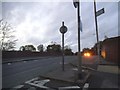
Whalebone Lane South at the junction of Crow Lane
Going over the Eastern Region railway
Image: © David Howard
Taken: 21 Oct 2017
0.13 miles
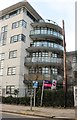
3
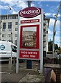
Sign for the Tollgate Tavern
See Image] for context.
Image: © JThomas
Taken: 22 Aug 2022
0.14 miles
5
Chadwell Heath: Railway line east of Chadwell Heath station
A One Railway stopping train bound for Liverpool Street approaches Chadwell Heath station from the Romford direction. The photo was taken through the signal gantries to the east of the footbridge which connects Heath Road with Selinas Lane.
Image: © Nigel Cox
Taken: 30 Nov 2007
0.15 miles
7
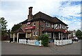
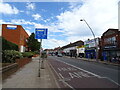
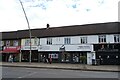
The Tollgate Tavern
On High Road.
See Image] for sign.
Image: © JThomas
Taken: 22 Aug 2022
0.15 miles
8
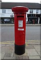
George V postbox on High Road
Postbox No. RM6 126.
Image: © JThomas
Taken: 22 Aug 2022
0.15 miles