1
Convenience store on High Road
Showing position of Postbox No. RM6 75.
See
Image] for postbox.
Image: © JThomas
Taken: 22 Aug 2022
0.14 miles
2
George V postbox on High Road
Postbox No. RM6 75.
See
Image] for context.
Image: © JThomas
Taken: 22 Aug 2022
0.14 miles
3
Houses on High Road, Chadwell Heath
Image: © David Howard
Taken: 4 Nov 2017
0.15 miles
4
Chadwell Heath Community Centre
Image: © David Howard
Taken: 4 Nov 2017
0.15 miles
5
New apartments on Whalebone Lane
On this site at the junction of Whalebone Lane, Chadwell Heath High Road and London Road, opposite the Tollgate pub, once stood a used car lot and a massage sauna parlour, which caught fire in the 1980s and remained in its burnt state without a roof ever since. A few years ago, however, these new apartments were constructed on the site. I have mixed feelings about this to be honest. It is a good job, as the burnt out building really did look something of an eyesore, but it's also a memory that died - there is no trace of the original building left on the site now. View taken looking north-northeast across to Whalebone Lane from Chadwell Heath High Road.
Image: © Robert Lamb
Taken: 5 Aug 2009
0.15 miles
6
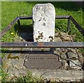
Water Pump, Chadwell Heath
19th Century Water Pump, High Road, Chadwell Heath.
Image: © Snidge
Taken: 10 Feb 2007
0.15 miles
7
Homes under the hammer
In this case not the auctioneer's hammer but the demolition contractors. It does look ready for it.
Image: © David Howard
Taken: 9 Mar 2019
0.16 miles
8
Flats on High Road, Chadwell Heath
Image: © David Howard
Taken: 9 Mar 2019
0.17 miles
9
Chad End Court, Chadwell Heath
Chad End Court is on the corner of London Road (A118) and Kings Avenue.
Image: © Marathon
Taken: 29 Dec 2016
0.18 miles
10
Old Boundary Marker by the A118, London Road, Romford parish
Municipal Boundary Marker - the Havering Stone by the A118, in parish of Romford (Havering District), London Road, North side, between pavement and brick wall. Surrounded by railings.
Grade II listed.
List Entry Number: 1300403 https://historicengland.org.uk/listing/the-list/list-entry/1300403
Surveyed
Milestone Society National ID: EX_HAVE03pb
Image: © Milestone Society
Taken: Unknown
0.19 miles


