1
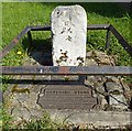
Water Pump, Chadwell Heath
19th Century Water Pump, High Road, Chadwell Heath.
Image: © Snidge
Taken: 10 Feb 2007
0.17 miles
2
Convenience store on High Road
Showing position of Postbox No. RM6 75.
See
Image] for postbox.
Image: © JThomas
Taken: 22 Aug 2022
0.17 miles
3
Chad End Court, Chadwell Heath
Chad End Court is on the corner of London Road (A118) and Kings Avenue.
Image: © Marathon
Taken: 29 Dec 2016
0.18 miles
4
George V postbox on High Road
Postbox No. RM6 75.
See
Image] for context.
Image: © JThomas
Taken: 22 Aug 2022
0.18 miles
5
Houses on High Road, Chadwell Heath
Image: © David Howard
Taken: 4 Nov 2017
0.18 miles
6
View from London Road
On this stretch of London Road there are no houses on the north side between Chadwell Heath here and Romford except for Crown Cottages. I am standing here just in the Borough of Barking & Dagenham looking into the Green Belt of Havering. The white tower on the skyline to the right belongs to the water tower at Havering-atte-Bower.
Image: © Marathon
Taken: 29 Dec 2016
0.18 miles
7
The Havering Stone
The Havering Stone, erected in 1642 on the London Road, A118 between Chadwell Heath and Romford. Boundary marker of the Liberty of Havering-atte-Bower. Stone is approx 15 inches high.
Image: © Snidge
Taken: 10 Feb 2007
0.18 miles
8
Old Boundary Marker by the A118, London Road, Romford parish
Municipal Boundary Marker - the Havering Stone by the A118, in parish of Romford (Havering District), London Road, North side, between pavement and brick wall. Surrounded by railings.
Grade II listed.
List Entry Number: 1300403 https://historicengland.org.uk/listing/the-list/list-entry/1300403
Surveyed
Milestone Society National ID: EX_HAVE03pb
Image: © Milestone Society
Taken: Unknown
0.19 miles
9
Coal Duty Boundary Post
The Coal Duty boundary post, High Road, Chadwell Heath. Erected 1861 (Restored 1991)
Image: © Snidge
Taken: 10 Feb 2007
0.19 miles
10
London Road, Chadwell Heath
Image: © David Howard
Taken: 4 Nov 2017
0.19 miles


