1
View from London Road by Crown Cottages
On this stretch of London Road there are no houses on the north side between Chadwell Heath and Romford except for Crown Cottages. The tower block on the skyline is next to Whalebone Lane North. The aerial view shows the land beyond the fence as a golf course although it looks like it could have been landfill in the not too distant past.
Image: © Marathon
Taken: 29 Dec 2016
0.13 miles
2
View from London Road
On this stretch of London Road there are no houses on the north side between Chadwell Heath here and Romford except for Crown Cottages. I am standing here just in the Borough of Barking & Dagenham looking into the Green Belt of Havering. The white tower on the skyline to the right belongs to the water tower at Havering-atte-Bower.
Image: © Marathon
Taken: 29 Dec 2016
0.14 miles
3
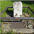
The Havering Stone
The Havering Stone, erected in 1642 on the London Road, A118 between Chadwell Heath and Romford. Boundary marker of the Liberty of Havering-atte-Bower. Stone is approx 15 inches high.
Image: © Snidge
Taken: 10 Feb 2007
0.16 miles
4
Coal Duty Boundary Post
The Coal Duty boundary post, High Road, Chadwell Heath. Erected 1861 (Restored 1991)
Image: © Snidge
Taken: 10 Feb 2007
0.16 miles
5
Chad End Court, Chadwell Heath
Chad End Court is on the corner of London Road (A118) and Kings Avenue.
Image: © Marathon
Taken: 29 Dec 2016
0.16 miles
6
Old Boundary Marker by the A118, London Road, Romford parish
Municipal Boundary Marker - the Havering Stone by the A118, in parish of Romford (Havering District), London Road, North side, between pavement and brick wall. Surrounded by railings.
Grade II listed.
List Entry Number: 1300403 https://historicengland.org.uk/listing/the-list/list-entry/1300403
Surveyed
Milestone Society National ID: EX_HAVE03pb
Image: © Milestone Society
Taken: Unknown
0.16 miles
7
Water Pump, Chadwell Heath
19th Century Water Pump, High Road, Chadwell Heath.
Image: © Snidge
Taken: 10 Feb 2007
0.17 miles
8
London Road, Chadwell Heath
Image: © David Howard
Taken: 4 Nov 2017
0.18 miles
9
Coal duty boundary marker, south side of London Road
Coal duty boundary marker
Milestone Society National ID: EX_CTROM03bm
Image: © Paul Jones
Taken: 12 Oct 2020
0.18 miles
10
Convenience store on High Road
Showing position of Postbox No. RM6 75.
See
Image] for postbox.
Image: © JThomas
Taken: 22 Aug 2022
0.20 miles


