IMAGES TAKEN NEAR TO
Chadville Gardens, ROMFORD, RM6 5UB
Introduction
This page details the photographs taken nearby to Chadville Gardens, RM6 5UB by members of the Geograph project.
The Geograph project started in 2005 with the aim of publishing, organising and preserving representative images for every square kilometre of Great Britain, Ireland and the Isle of Man.

There are currently over 7.5m images from over14,400 individuals and you can help contribute to the project by visiting https://www.geograph.org.uk
Image Map
Images are licensed for reuse under creativecommons.org/licenses/by-sa/2.0
Notes
- Clicking on the map will re-center to the selected point.
- The higher the marker number, the further away the image location is from the centre of the postcode.
Image Listing (5 Images Found)
Images are licensed for reuse under creativecommons.org/licenses/by-sa/2.0
Image
Details
Distance
1
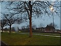
Green verge on Eastern Avenue, Chadwell Heath
Image: © David Howard
Taken: 5 Mar 2017
0.23 miles
2
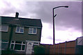
Leaning concrete lamp post in Newton Industrial Estate, Little Heath
Along the Eastern Avenue, in the Newton Industrial Estate just before you pass Woodcraft Conservatories, this (badly leaning) concrete lamp post with Philips SGS203 lantern can be seen. It looks as if the fence is the only thing preventing the lamp post from falling onto that house! I can't really see why this lamp post is here to be honest, as a floodlight has been fitted onto it, clearly meaning that the lamp post doesn't work any more. A thing which strikes me as weird with regards to the gazetteer information is that it says it is 3km from Collier Row. Why not just say something more well known among motorists, like Little Heath?
Image: © Robert Lamb
Taken: 12 Aug 2008
0.24 miles
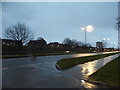
4
St Chad's Park
There is good signage for walkers in this area, but distances are measured in minutes - what standard speed is assumed?
Image: © Robin Webster
Taken: 2 Apr 2011
0.25 miles
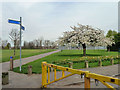
5
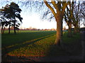
St Chad's Park
St Chad's Park is the oldest park in the Borough of Barking & Dagenham, having its origins in 1831 when the Crown granted four acres of Chadwell Heath as allotments to the poor. The remainder of the Heath was enclosed in 1866 with another three acres designated for public use and the park reached its present extent in 1928 when adjacent farmland was added. The Mayes Brook once flowed above ground along part of the park's northern boundary but has now been culverted.
Image: © Marathon
Taken: 29 Dec 2016
0.25 miles