IMAGES TAKEN NEAR TO
Kingston Hill Avenue, ROMFORD, RM6 5QD
Introduction
This page details the photographs taken nearby to Kingston Hill Avenue, RM6 5QD by members of the Geograph project.
The Geograph project started in 2005 with the aim of publishing, organising and preserving representative images for every square kilometre of Great Britain, Ireland and the Isle of Man.

There are currently over 7.5m images from over14,400 individuals and you can help contribute to the project by visiting https://www.geograph.org.uk
Image Map
Images are licensed for reuse under creativecommons.org/licenses/by-sa/2.0
Notes
- Clicking on the map will re-center to the selected point.
- The higher the marker number, the further away the image location is from the centre of the postcode.
Image Listing (13 Images Found)
Images are licensed for reuse under creativecommons.org/licenses/by-sa/2.0
Image
Details
Distance
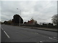
1
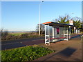
Bus stops on Billet Road
Furze House Farm is the last remnant in Barking & Dagenham of the agricultural landscape which predominated until the 1920s. Although the fields here serve as a reminder of how most of Barking & Dagenham once looked, this particular farmland is of relatively recent origin. In the early 19th century this land lay within Hainault Forest. The name 'Furze House' refers to the heathy nature of the Forest, furze being an old name for gorse. It was only after the removal of the Forest's legal protection in 1851 that this area was turned over to agricultural use. The area of open countryside here in the north of Barking & Dagenham was reduced to the current extent around 1960 when the Marks Gate housing estate to the south was completed.
Billet Road is a classic example of how the Green Belt works. To the south is the estate of Marks Gate while across the road is open countryside. The land just across the road here belongs to Furze House Farm. The two tower blocks in the distance are at Hainault.
Image: © Marathon
Taken: 29 Dec 2016
0.10 miles
2
Billet Road
Furze Hill Farm is the last remnant in Barking & Dagenham of the agricultural landscape which predominated until the 1920s. Although the fields here serve as a reminder of how most of Barking & Dagenham once looked, this particular farmland is of relatively recent origin. In the early 19th century this land lay within Hainault Forest. The name 'Furze House' refers to the heathy nature of the Forest, furze being an old name for gorse. It was only after the removal of the Forest's legal protection in 1851 that this area was turned over to agricultural use. The area of open countryside here in the north of Barking & Dagenham was reduced to the current extent around 1960 when the Marks Gate housing estate to the south was completed.
Billet Road is a classic example of how the Green Belt works. To the south (on the right) is the estate of Marks Gate while across the road (to the left) is open countryside. The land just across the road here belongs to Furze House Farm. This is at the junction with Hazel Grove.
Image: © Marathon
Taken: 29 Dec 2016
0.14 miles
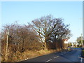
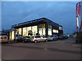
4

Richard Scott Motors, Whalebone Lane North
The view looked very much as it had 16 years ago Image but its significance for me is that it is where my paternal great-grandmother once lived, in the house behind the cars.
Image: © John Baker
Taken: 17 Oct 2013
0.17 miles
5
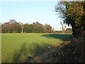
View from Billet Road
Furze Hill Farm is the last remnant in Barking & Dagenham of the agricultural landscape which predominated until the 1920s. Although the fields here serve as a reminder of how most of Barking & Dagenham once looked, this particular farmland is of relatively recent origin. In the early 19th century this land lay within Hainault Forest. The name 'Furze House' refers to the heathy nature of the Forest, furze being an old name for gorse. It was only after the removal of the Forest's legal protection in 1851 that this area was turned over to agricultural use. The area of open countryside here in the north of Barking & Dagenham was reduced to the current extent around 1960 when the Marks Gate housing estate to the south was completed.
Billet Road is a classic example of how the Green Belt works. To the south is the estate of Marks Gate while across the road is open countryside. The land just across the road here belongs to Furze House Farm. Hainault Forest Country Park is on the horizon.
Image: © Marathon
Taken: 29 Dec 2016
0.18 miles
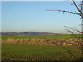
7
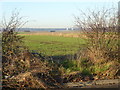
Furze House Farm
Furze House Farm is the last remnant in Barking & Dagenham of the agricultural landscape which predominated until the 1920s. Although the fields here serve as a reminder of how most of Barking & Dagenham once looked, this particular farmland is of relatively recent origin. In the early 19th century this land lay within Hainault Forest. The name 'Furze House' refers to the heathy nature of the Forest, furze being an old name for gorse. It was only after the removal of the Forest's legal protection in 1851 that this area was turned over to agricultural use. The area of open countryside here in the north of Barking & Dagenham was reduced to the current extent around 1960 when the Marks Gate housing estate to the south was completed.
Billet Road is a classic example of how the Green Belt works. To the south is the estate of Marks Gate while across the road as seen here is open countryside. The land here belongs to Furze House Farm which lies just the other side of the trees.
Image: © Marathon
Taken: 29 Dec 2016
0.19 miles
8
View looking across Billet Road
Furze Hill Farm is the last remnant in Barking & Dagenham of the agricultural landscape which predominated until the 1920s. Although the fields here serve as a reminder of how most of Barking & Dagenham once looked, this particular farmland is of relatively recent origin. In the early 19th century this land lay within Hainault Forest. The name 'Furze House' refers to the heathy nature of the Forest, furze being an old name for gorse. It was only after the removal of the Forest's legal protection in 1851 that this area was turned over to agricultural use. The area of open countryside here in the north of Barking & Dagenham was reduced to the current extent around 1960 when the Marks Gate housing estate to the south was completed.
Billet Road is a classic example of how the Green Belt works. To the south is the estate of Marks Gate while across the road is open countryside. The land just across the road here belongs to Furze House Farm. The two tower blocks in the distance are at Hainault.
Image: © Marathon
Taken: 29 Dec 2016
0.19 miles
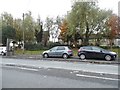
9
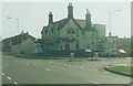
The Crooked Billet: 1997
Situated in Billet Road.
Image: © John Baker
Taken: 2 Apr 1997
0.19 miles
10
Whalebone Lane North, Marks Gate
Looking towards Marks Gate Cemetery
Image: © David Howard
Taken: 4 Nov 2017
0.20 miles