IMAGES TAKEN NEAR TO
Rose Lane, ROMFORD, RM6 5NR
Introduction
This page details the photographs taken nearby to Rose Lane, RM6 5NR by members of the Geograph project.
The Geograph project started in 2005 with the aim of publishing, organising and preserving representative images for every square kilometre of Great Britain, Ireland and the Isle of Man.

There are currently over 7.5m images from over14,400 individuals and you can help contribute to the project by visiting https://www.geograph.org.uk
Image Map
Images are licensed for reuse under creativecommons.org/licenses/by-sa/2.0
Notes
- Clicking on the map will re-center to the selected point.
- The higher the marker number, the further away the image location is from the centre of the postcode.
Image Listing (8 Images Found)
Images are licensed for reuse under creativecommons.org/licenses/by-sa/2.0
Image
Details
Distance
1
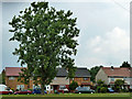
Houses on Sheepcotes Road
Fronted by a rather tall tree which looks like a species of Lime.
Image: © Robin Webster
Taken: 11 Jun 2011
0.11 miles
2
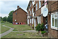
Hutchinson Court
A group of several similar blocks of flats on this estate.
Image: © Robin Webster
Taken: 11 Jun 2011
0.20 miles
3
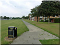
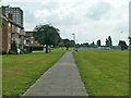
A monotonous path
The long green (also monotonous) is a buffer between the A12 on the left and flats south of Padnall Road on the right.
Image: © Robin Webster
Taken: 11 Jun 2011
0.21 miles
4
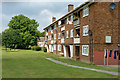
Hutchinson Court
One of several similar blocks of flats on this estate.
Image: © Robin Webster
Taken: 11 Jun 2011
0.22 miles
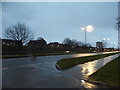
5
Path parallel with A12
Looking towards the A12/A1112 (Whalebone Lane) junction.
Image: © Robin Webster
Taken: 11 Jun 2011
0.24 miles
7
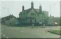
The Crooked Billet: 1997
Situated in Billet Road.
Image: © John Baker
Taken: 2 Apr 1997
0.24 miles
8
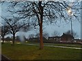
Green verge on Eastern Avenue, Chadwell Heath
Image: © David Howard
Taken: 5 Mar 2017
0.25 miles