IMAGES TAKEN NEAR TO
Nursery Close, ROMFORD, RM6 4LB
Introduction
This page details the photographs taken nearby to Nursery Close, RM6 4LB by members of the Geograph project.
The Geograph project started in 2005 with the aim of publishing, organising and preserving representative images for every square kilometre of Great Britain, Ireland and the Isle of Man.

There are currently over 7.5m images from over14,400 individuals and you can help contribute to the project by visiting https://www.geograph.org.uk
Image Map
Images are licensed for reuse under creativecommons.org/licenses/by-sa/2.0
Notes
- Clicking on the map will re-center to the selected point.
- The higher the marker number, the further away the image location is from the centre of the postcode.
Image Listing (33 Images Found)
Images are licensed for reuse under creativecommons.org/licenses/by-sa/2.0
Image
Details
Distance
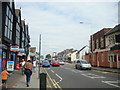
1
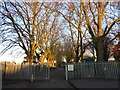
Park Villas
Park Villas, Chadwell Heath, overlooking St. Chad's Park
Image: © Snidge
Taken: 10 Feb 2007
0.03 miles
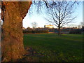
2
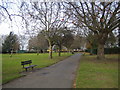
Chadwell Heath: St Chad's Park
This is the oldest park now maintained by the London Borough of Barking and Dagenham and dates from around 1830.
Image: © Nigel Cox
Taken: 30 Nov 2007
0.04 miles
3
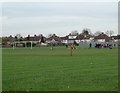
St Chad's Park
Some Kids at footie practice in St Chad's Park Chadwell Heath
Image: © Glyn Baker
Taken: 2 Dec 2005
0.06 miles
4
Entrance to St Chad's Park from Park Lane
St Chad's Park is the oldest park in the Borough of Barking & Dagenham, having its origins in 1831 when the Crown granted four acres of Chadwell Heath as allotments to the poor. The remainder of the Heath was enclosed in 1866 with another three acres designated for public use and the park reached its present extent in 1928 when adjacent farmland was added. The Mayes Brook once flowed above ground along part of the park's northern boundary but has now been culverted.
Image: © Marathon
Taken: 29 Dec 2016
0.07 miles
5
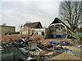
Demolition site, Chadwell Heath
This was St Chads Infant School.
Image: © Robin Webster
Taken: 2 Apr 2011
0.08 miles
6
Chadwell Heath: Japan Road
There is only one other Japan Road in the UK, (in Gainsborough, Lincs), and a house in this short road was the home of Eva Hart, the Titanic survivor. There is an entrance to St Chad's Park at the end of the road.
Image: © Nigel Cox
Taken: 30 Nov 2007
0.08 miles
7
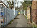
Footpath from High Road to Mayfair Avenue or Park Lane
Image: © Robin Webster
Taken: 2 Apr 2011
0.08 miles
8
St Chad's Park
St Chad's Park is the oldest park in the Borough of Barking & Dagenham, having its origins in 1831 when the Crown granted four acres of Chadwell Heath as allotments to the poor. The remainder of the Heath was enclosed in 1866 with another three acres designated for public use and the park reached its present extent in 1928 when adjacent farmland was added. The Mayes Brook once flowed above ground along part of the park's northern boundary but has now been culverted.
Image: © Marathon
Taken: 29 Dec 2016
0.10 miles
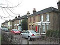
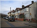
9
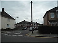
Chadwell Heath Lane at the junction of Arthur Road
Image: © David Howard
Taken: 4 Nov 2017
0.10 miles