IMAGES TAKEN NEAR TO
High Road, ROMFORD, RM6 4BB
Introduction
This page details the photographs taken nearby to High Road, RM6 4BB by members of the Geograph project.
The Geograph project started in 2005 with the aim of publishing, organising and preserving representative images for every square kilometre of Great Britain, Ireland and the Isle of Man.

There are currently over 7.5m images from over14,400 individuals and you can help contribute to the project by visiting https://www.geograph.org.uk
Image Map
Images are licensed for reuse under creativecommons.org/licenses/by-sa/2.0
Notes
- Clicking on the map will re-center to the selected point.
- The higher the marker number, the further away the image location is from the centre of the postcode.
Image Listing (40 Images Found)
Images are licensed for reuse under creativecommons.org/licenses/by-sa/2.0
Image
Details
Distance
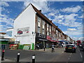
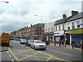
2
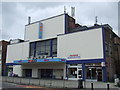
Bingo hall, Chadwell Heath
A former cinema now used as a bingo hall, on Chadwell Heath High Road.
Image: © Malc McDonald
Taken: 2 Oct 2010
0.05 miles
3
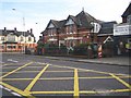
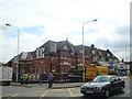
Chadwell Heath: The Eva Hart public house
Eva Hart? She was a survivor of the Titanic disaster in 1912 and lived in nearby Japan Road. She became a magistrate and was awarded the MBE. She died in 1996. Quite what she would think of the conversion of Chadwell Heath's former Police Station (for this is what the building is) into a Wetherspoon's outlet named after herself can only be speculated on!
The orange and peach coloured building is the Coopers Arms. However the two pubs are in different London Boroughs, the Eva Hart in Redbridge and the Coopers Arms in Barking and Dagenham.
Image: © Nigel Cox
Taken: 30 Nov 2007
0.10 miles
4
Barclays Bank on the corner of Chadwell Heath Lane
Image: © David Howard
Taken: 4 Nov 2017
0.11 miles
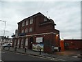
5
The Eva Hart public house, Chadwell Heath
Image: © Stacey Harris
Taken: 23 Jul 2010
0.12 miles
6
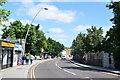
Station Road, Chadwell Heath
Or, as I had it when I was growing up there, Station Hill.
Image: © Trevor Harris
Taken: 27 May 2022
0.13 miles
8
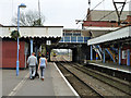
On Chadwell Heath station
A Shenfield train is heading away, next stop Romford. It is nice to see original decorative valances surviving on the canopies. There is, or was, an amazing variety of patterns to be seen, even at stations on the same line, seemingly at the whim of the carpenter.
Image: © Robin Webster
Taken: 2 Apr 2011
0.14 miles
9
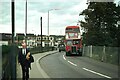
The northern approach to Chadwell Heath Station ? 1978
Note the lack of a pedestrian walkway on the far side of the road, which has since been improved. The iconic London Transport RT bus was only 7 ft 6 inches wide, considerably less than modern buses at 2.50 metres (8 ft 2 inches), emphasising the narrowness of the carriageway. Hardly surprising that the fence post appear to have taken a battering (probably not from buses!). This is one of a series of views featuring buses in the 60s, 70s, and 80s. http://www.geograph.org.uk/search.php?i=137652761 . RT1989 is operating on route 62 to Gascoigne Estate.
Image: © Alan Murray-Rust
Taken: 12 Sep 1978
0.14 miles
10
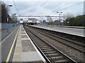
Chadwell Heath railway station, Greater London, 2013
Opened in 1864 by the Great Eastern Railway on its line from London Liverpool Street to Shenfield.
View east towards Romford and Shenfield. See Image for a 2020 view from a similar camera position.
Image: © Nigel Thompson
Taken: 19 Apr 2013
0.14 miles