IMAGES TAKEN NEAR TO
Highfield Road, ROMFORD, RM5 3SA
Introduction
This page details the photographs taken nearby to Highfield Road, RM5 3SA by members of the Geograph project.
The Geograph project started in 2005 with the aim of publishing, organising and preserving representative images for every square kilometre of Great Britain, Ireland and the Isle of Man.

There are currently over 7.5m images from over14,400 individuals and you can help contribute to the project by visiting https://www.geograph.org.uk
Image Map
Images are licensed for reuse under creativecommons.org/licenses/by-sa/2.0
Notes
- Clicking on the map will re-center to the selected point.
- The higher the marker number, the further away the image location is from the centre of the postcode.
Image Listing (4 Images Found)
Images are licensed for reuse under creativecommons.org/licenses/by-sa/2.0
Image
Details
Distance

2
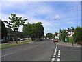
Chase Cross Road, Collier Row, Romford, Essex
Looking west towards the town centre.
Image: © John Winfield
Taken: 11 Jul 2005
0.20 miles
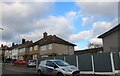
4

View down Highfield Road, Collier Row
In the distance, the Canary Wharf complex is to the left and the Shard to the right.
Image: © Robin Webster
Taken: 30 Jun 2012
0.25 miles