IMAGES TAKEN NEAR TO
Clitheroe Road, ROMFORD, RM5 2SL
Introduction
This page details the photographs taken nearby to Clitheroe Road, RM5 2SL by members of the Geograph project.
The Geograph project started in 2005 with the aim of publishing, organising and preserving representative images for every square kilometre of Great Britain, Ireland and the Isle of Man.

There are currently over 7.5m images from over14,400 individuals and you can help contribute to the project by visiting https://www.geograph.org.uk
Image Map
Images are licensed for reuse under creativecommons.org/licenses/by-sa/2.0
Notes
- Clicking on the map will re-center to the selected point.
- The higher the marker number, the further away the image location is from the centre of the postcode.
Image Listing (10 Images Found)
Images are licensed for reuse under creativecommons.org/licenses/by-sa/2.0
Image
Details
Distance
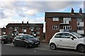
1

Pinewoods, Collier Row
Suburban pub on the very edge of the built-up area.
Image: © Des Blenkinsopp
Taken: 8 Apr 2015
0.09 miles
2

Dodgy Looking Pond
I'm sure healthy ponds shouldn't be this colour. It seems to be some sort of plant growth.
Update :- Thanks to Mick Crawley for identifying the plant responsible "The red plant cover floating on the pond is the alien Water Fern Azolla filiculoides"
Image: © Des Blenkinsopp
Taken: 8 Apr 2015
0.09 miles
3
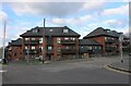
New flats on St Johns Road, Collier Row
These were finished in 2018
Image: © David Howard
Taken: 6 Mar 2022
0.10 miles
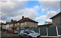

7

Firbank Road
Part of a short detour to avoid an especially muddy bit of the London Loop path.
Image: © Des Blenkinsopp
Taken: 8 Apr 2015
0.23 miles
8
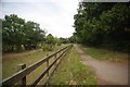
Clockhouse Lane
This is the western boundary of Havering Country Park http://www.wildessex.net/sites/Havering%20CP.htm
Image: © Glyn Baker
Taken: 16 Oct 2011
0.24 miles

10
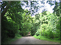
Havering Country Park, Collier Row, Essex
Believed this lane was called Wellingtonia Avenue (named after the large evergreen wellingtonia trees that lined this lane). Now part of Havering Council countryside park.
Image: © John Winfield
Taken: 11 Jul 2005
0.25 miles