IMAGES TAKEN NEAR TO
Orange Tree Hill, ROMFORD, RM4 1PJ
Introduction
This page details the photographs taken nearby to Orange Tree Hill, RM4 1PJ by members of the Geograph project.
The Geograph project started in 2005 with the aim of publishing, organising and preserving representative images for every square kilometre of Great Britain, Ireland and the Isle of Man.

There are currently over 7.5m images from over14,400 individuals and you can help contribute to the project by visiting https://www.geograph.org.uk
Image Map
Images are licensed for reuse under creativecommons.org/licenses/by-sa/2.0
Notes
- Clicking on the map will re-center to the selected point.
- The higher the marker number, the further away the image location is from the centre of the postcode.
Image Listing (83 Images Found)
Images are licensed for reuse under creativecommons.org/licenses/by-sa/2.0
Image
Details
Distance
1
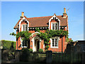
Bower Farm Cottage
This splendidly ornate small house is on the edge of Havering-atte-Bower village.
Image: © Des Blenkinsopp
Taken: 8 Sep 2014
0.00 miles
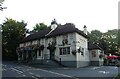
2
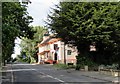
Orange Tree Public House June 2012
The building was repainted in late 2011 and dates from 1826 or before. The village is at the top of the hill.
Image: © Phil Gaskin
Taken: 19 Jun 2012
0.04 miles
3
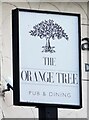
Sign for the Orange Tree Pub & Dining
See Image] for context.
Image: © JThomas
Taken: 26 Aug 2022
0.04 miles
4
The Orange Tree
At around 0.5 km north of joined up suburbia, this bright roadside inn could just about claim to be a country pub.
London seems to stop very suddenly in this direction.
Image: © Des Blenkinsopp
Taken: 8 Sep 2014
0.04 miles
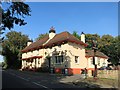
5
The Orange Tree Pub & Dining
On Orange Tree Hill.
See Image] for sign.
Image: © JThomas
Taken: 26 Aug 2022
0.05 miles
6
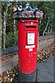
Yarn bombed George V postbox on Orange Tree Hill
Postbox No. RM4 306.
Image: © JThomas
Taken: 26 Aug 2022
0.07 miles
7
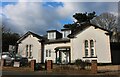
White Lodge on Orange Tree Hill, Havering-atte-Bower
Image: © David Howard
Taken: 6 Mar 2022
0.09 miles
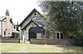
9
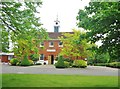
The Old Coach House, The Bower House, Havering-atte-Bower, Essex
Designed and built at the same time as the Bower House, which sits nearby. It is square in plan and has a central ridged roof from which rises a square clock tower and belfry. The clock is of twelve hour design and carries a single hour hand. The building now houses the administration office for the Christian training Centre that occupies the estate.
Image: © Derek Voller
Taken: 31 May 2014
0.12 miles
10
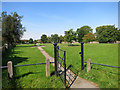
Gate to the Green
At the southern end of the village.
Image: © Des Blenkinsopp
Taken: 8 Sep 2014
0.13 miles