IMAGES TAKEN NEAR TO
Woodbridge Close, ROMFORD, RM3 9UR
Introduction
This page details the photographs taken nearby to Woodbridge Close, RM3 9UR by members of the Geograph project.
The Geograph project started in 2005 with the aim of publishing, organising and preserving representative images for every square kilometre of Great Britain, Ireland and the Isle of Man.

There are currently over 7.5m images from over14,400 individuals and you can help contribute to the project by visiting https://www.geograph.org.uk
Image Map (Loading...)


Getting Data...Please wait
Leaflet Map data © OpenStreetMap
Images are licensed for reuse under creativecommons.org/licenses/by-sa/2.0
Notes
- Clicking on the map will re-center to the selected point.
- The higher the marker number, the further away the image location is from the centre of the postcode.
Image Listing (24 Images Found)
Images are licensed for reuse under creativecommons.org/licenses/by-sa/2.0
Image
Details
Distance
2
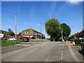
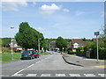
Woodbridge Lane, Harold Hill
This is looking across from the parade of shops in Whitchurch Road.
Image: © Marathon
Taken: 14 Jun 2017
0.09 miles
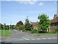
4
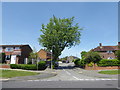
Bus stop in Tees Drive
Carter's Brook, a tributary of the Ingrebourne River, runs through the trees on the right and the London LOOP passes along the other side of the trees.
Image: © Marathon
Taken: 14 Jun 2017
0.13 miles
7
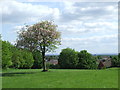
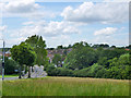
Park overlooking Harold Hill
This image was taken in a small recreation ground at Noak Hill, on a hillside with views over parts of North East London.
Image: © Malc McDonald
Taken: 25 May 2013
0.15 miles
8
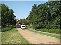
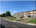
Harold Hill: Priory Road
The white van is parked at the bridge crossing over Carter's Brook.
Image: © Nigel Cox
Taken: 26 Aug 2013
0.15 miles
9
Grassland by Whitchurch Road, Harold Hill
Sloping down to Carter's Brook, with Little Hatter's Wood to the right.
Image: © Robin Webster
Taken: 30 Jun 2012
0.18 miles
10
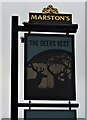
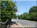
Sign for the Deers Rest
Image: © JThomas
Taken: 24 Aug 2022
0.19 miles