IMAGES TAKEN NEAR TO
Tring Walk, ROMFORD, RM3 9ET
Introduction
This page details the photographs taken nearby to Tring Walk, RM3 9ET by members of the Geograph project.
The Geograph project started in 2005 with the aim of publishing, organising and preserving representative images for every square kilometre of Great Britain, Ireland and the Isle of Man.

There are currently over 7.5m images from over14,400 individuals and you can help contribute to the project by visiting https://www.geograph.org.uk
Image Map
Images are licensed for reuse under creativecommons.org/licenses/by-sa/2.0
Notes
- Clicking on the map will re-center to the selected point.
- The higher the marker number, the further away the image location is from the centre of the postcode.
Image Listing (11 Images Found)
Images are licensed for reuse under creativecommons.org/licenses/by-sa/2.0
Image
Details
Distance
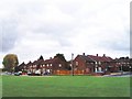
1

Houses on Whitchurch Road, Harold Hill
Image: © Robin Webster
Taken: 30 Jun 2012
0.14 miles
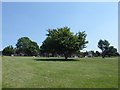
2
Grassland by Whitchurch Road, Harold Hill
Sloping down to Carter's Brook, with Little Hatter's Wood to the right.
Image: © Robin Webster
Taken: 30 Jun 2012
0.18 miles
3
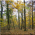
Hatter's Wood, The Manor Nature Reserve, Harold Hill
Image: © Roger Jones
Taken: 20 Nov 2016
0.18 miles
4
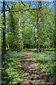
Bluebell Path in Hatters Wood
Hatters Wood is part of the Dagnam Park estate see http://www.havering.gov.uk/index.aspx?articleid=4487 and http://www.friendsofdagnampark.org.uk/ for more info.
Image: © Glyn Baker
Taken: 6 May 2010
0.19 miles
5
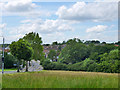
Priory Grove, Harold Hill
On the edge of suburbia here. Fields start beyond these houses.
Image: © Des Blenkinsopp
Taken: 8 Sep 2014
0.19 miles
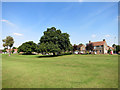
6
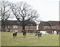
Parkland next to Priory Road, Harold Hill
This is at the northern end of Harold Hill. The grassland slopes down behind to Carter's Brook which is a tributary of the Ingrebourne River. The road at the top of the hill is Priory Grove.
Image: © Marathon
Taken: 14 Jun 2017
0.21 miles
7
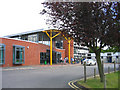
Havering College, Tring Gardens, Harold Hill, Essex
This is the Quarles Annex of the college
Image: © John Winfield
Taken: 13 Jun 2005
0.22 miles
8
Harold Hill Estate, Romford
Harold Hill was a large 'out-County' housing estate built by the London County Council during the early 1950s on a green field site in what was then Essex. The picture shows the junction of Chudleigh Road (left) and Broseley Road (right).
Image: © David Kemp
Taken: 18 Oct 2008
0.22 miles
9
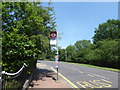
Bus stop in Tees Drive
Carter's Brook, a tributary of the Ingrebourne River, runs through the trees on the right and the London LOOP passes along the other side of the trees.
Image: © Marathon
Taken: 14 Jun 2017
0.23 miles