IMAGES TAKEN NEAR TO
Straight Road, ROMFORD, RM3 8XU
Introduction
This page details the photographs taken nearby to Straight Road, RM3 8XU by members of the Geograph project.
The Geograph project started in 2005 with the aim of publishing, organising and preserving representative images for every square kilometre of Great Britain, Ireland and the Isle of Man.

There are currently over 7.5m images from over14,400 individuals and you can help contribute to the project by visiting https://www.geograph.org.uk
Image Map
Images are licensed for reuse under creativecommons.org/licenses/by-sa/2.0
Notes
- Clicking on the map will re-center to the selected point.
- The higher the marker number, the further away the image location is from the centre of the postcode.
Image Listing (11 Images Found)
Images are licensed for reuse under creativecommons.org/licenses/by-sa/2.0
Image
Details
Distance
1
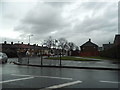
Straight Road looking towards Hilldene Avenue
Image: © David Howard
Taken: 5 Mar 2017
0.03 miles
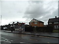

6
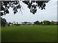
Recreation ground on the Harold Hill Estate
This recreation ground does not seem to have a name but Chatteris Avenue is behind where I am standing, Myrtle Road is to the left and Saddleworth Road is on the far side.
Image: © Marathon
Taken: 6 Sep 2017
0.19 miles
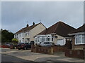
7

Recreation ground on the Harold Hill Estate
This recreation ground does not seem to have a name but Myrtle Road is behind where I am standing, and Chatteris Avenue is on the far side on the right.
Image: © Marathon
Taken: 6 Sep 2017
0.19 miles
9
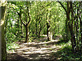
In Harold's Wood
The name may be not quite right, but it is something similar on the inviting board at the entrance. It turned out to be a very narrow belt of rather littered woodland bordering Broxhill Road, with no way through to anything beyond it to the west.
Image: © Robin Webster
Taken: 30 Jun 2012
0.21 miles
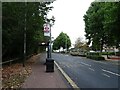
10
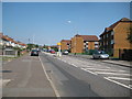
Harold Hill: Straight Road
It does exactly what it says on the tin..., running dead straight for about 1.2 miles NNW from Gallows Corner. However it was not always called Straight Road. Old Victorian large scale Ordnance Survey maps show the thoroughfare as Gallows Lane. Here the ubiquitous Gatso tries to make sure that the 30mph speed limit is observed.
Image: © Nigel Cox
Taken: 26 Aug 2013
0.23 miles