IMAGES TAKEN NEAR TO
Paignton Close, ROMFORD, RM3 8SF
Introduction
This page details the photographs taken nearby to Paignton Close, RM3 8SF by members of the Geograph project.
The Geograph project started in 2005 with the aim of publishing, organising and preserving representative images for every square kilometre of Great Britain, Ireland and the Isle of Man.

There are currently over 7.5m images from over14,400 individuals and you can help contribute to the project by visiting https://www.geograph.org.uk
Image Map
Images are licensed for reuse under creativecommons.org/licenses/by-sa/2.0
Notes
- Clicking on the map will re-center to the selected point.
- The higher the marker number, the further away the image location is from the centre of the postcode.
Image Listing (16 Images Found)
Images are licensed for reuse under creativecommons.org/licenses/by-sa/2.0
Image
Details
Distance
2

A zebra/toucan hybrid crossing
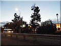
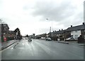
As you turn onto the A12 Colchester Road from the Gallows Corner Roundabout, this strange hybrid crossing hones into view. It's a toucan crossing in the respect that it is light-controlled, but it is also partly a zebra crossing as it is lit with an Urbis ZX3 Zebra streetlight (a special streetlight whose optics are specifically designed for zebra crossings). This just goes to show how important so called "white" lighting is on crossing points to improve safety these days. The taller streetlight in the background is a Philips MA60 dating back to the 1970s, and behind that is a modern Thorn Riviera casual replacement, which would've replaced a failed MA60. View taken looking north-northeast in the centre of the square from the A12 Colchester Road.
Image: © Robert Lamb
Taken: 1 May 2009
0.15 miles
5
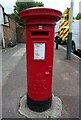
George VI postbox on Straight Road, Romford
Postbox No. RM3 215.
Image: © JThomas
Taken: 24 Aug 2022
0.18 miles
7
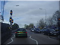
Pedestrian lights on Colchester Road, Harold Wood
Image: © David Howard
Taken: 15 May 2012
0.18 miles
8
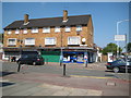
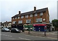
Harold Hill: Masefield Crescent
This small parade of neighbourhood shops is on the north side of Masefield Cresecent at the junction with Straight Road. The current shops are, from left to right, Terrys Gents' Barbers and Ladies' Hair Stylists, The Bread Basket, the Crescent Pharmacy and Sunny News.
Image: © Nigel Cox
Taken: 26 Aug 2013
0.18 miles
9
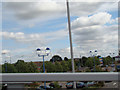
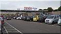
View of the A12 Colchester Road from Gallows Corner Flyover
The main view that greets you as you cross the Gallows Corner Flyover on the A127 eastbound is the A12 Colchester Road and several retail outlets, including several sofa superstores such as DFS, and there is a Comet superstore just out of shot to the right. According to a sign on the side of this store facing the A127, there is also to be a new Argos store here very soon. View taken looking east-northeast along the A12 Colchester Road.
Image: © Robert Lamb
Taken: 30 Aug 2009
0.19 miles
10
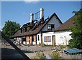
Harold Wood: The former Plough at Gallows Corner
Virtually up to the start of the Second World War the Plough was an isolated pub at Gallows Corner on the Colchester Road, most frequently used by Eastenders as a watering hole on the way to visit the delights of Southend-on-Sea. But with the post-war residential development of Harold Wood it became a local pub. It eventually ceased trading several years ago, and a devastating fire in April 2011 reduced it to the current burnt-out shell. Plans are currently being drawn up to demolish what remains of the structure and to build a new KFC outlet in its place.
Image: © Nigel Cox
Taken: 26 Aug 2013
0.19 miles