IMAGES TAKEN NEAR TO
Halesworth Road, ROMFORD, RM3 8QD
Introduction
This page details the photographs taken nearby to Halesworth Road, RM3 8QD by members of the Geograph project.
The Geograph project started in 2005 with the aim of publishing, organising and preserving representative images for every square kilometre of Great Britain, Ireland and the Isle of Man.

There are currently over 7.5m images from over14,400 individuals and you can help contribute to the project by visiting https://www.geograph.org.uk
Image Map
Images are licensed for reuse under creativecommons.org/licenses/by-sa/2.0
Notes
- Clicking on the map will re-center to the selected point.
- The higher the marker number, the further away the image location is from the centre of the postcode.
Image Listing (6 Images Found)
Images are licensed for reuse under creativecommons.org/licenses/by-sa/2.0
Image
Details
Distance
1
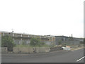
Derelict Factory, Spilsby Road, Harold Hill, Essex
Image: © John Winfield
Taken: 20 Jun 2005
0.15 miles
2
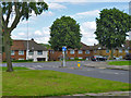
Houses on Gooshays Drive, Harold Hill
Opposite the end of Faringdon Avenue.
Image: © Robin Webster
Taken: 30 Jun 2012
0.16 miles
3
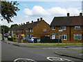
Houses on Dewsbury Road, Harold Hill
On the corner of Guildford Road.
Image: © Robin Webster
Taken: 30 Jun 2012
0.18 miles
4
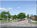
St. Neot's Road, Harold Hill
Harold Hill is a large housing estate near Romford.
Image: © Malc McDonald
Taken: 25 May 2013
0.23 miles
5
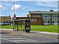
Harold Hill Community Centre bus stop
The grass area has now been built on.
Image: © Robin Webster
Taken: 30 Jun 2012
0.24 miles
6
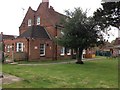
The Morris Dancer, Harold Hill
An unusually named pub, I think, and perhaps a rather incongruous position in the middle of a housing estate.
Image: © Trevor Harris
Taken: 11 May 2013
0.25 miles