IMAGES TAKEN NEAR TO
Archway, ROMFORD, RM3 7EH
Introduction
This page details the photographs taken nearby to Archway, RM3 7EH by members of the Geograph project.
The Geograph project started in 2005 with the aim of publishing, organising and preserving representative images for every square kilometre of Great Britain, Ireland and the Isle of Man.

There are currently over 7.5m images from over14,400 individuals and you can help contribute to the project by visiting https://www.geograph.org.uk
Image Map
Images are licensed for reuse under creativecommons.org/licenses/by-sa/2.0
Notes
- Clicking on the map will re-center to the selected point.
- The higher the marker number, the further away the image location is from the centre of the postcode.
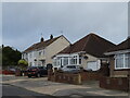
Image Listing (5 Images Found)
Images are licensed for reuse under creativecommons.org/licenses/by-sa/2.0
Image
Details
Distance

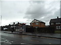
3

Dryden Towers, Heaton Avenue, Harold Hill, Essex
The second tower block is Kipling Towers
Image: © John Winfield
Taken: 20 Jun 2005
0.19 miles
4
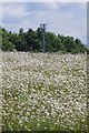
Oxeye Daisy & Cellular Mast
Somewhere between the camera position and the mast should be a triangulation pillar. The site is very well fenced. The display of Oxeye Daisies is on a par with my front lawn!
Image: © Glyn Baker
Taken: 9 Jun 2020
0.22 miles