IMAGES TAKEN NEAR TO
Bell Avenue, ROMFORD, RM3 7BS
Introduction
This page details the photographs taken nearby to Bell Avenue, RM3 7BS by members of the Geograph project.
The Geograph project started in 2005 with the aim of publishing, organising and preserving representative images for every square kilometre of Great Britain, Ireland and the Isle of Man.

There are currently over 7.5m images from over14,400 individuals and you can help contribute to the project by visiting https://www.geograph.org.uk
Image Map
Images are licensed for reuse under creativecommons.org/licenses/by-sa/2.0
Notes
- Clicking on the map will re-center to the selected point.
- The higher the marker number, the further away the image location is from the centre of the postcode.
Image Listing (4 Images Found)
Images are licensed for reuse under creativecommons.org/licenses/by-sa/2.0
Image
Details
Distance
1
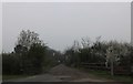
Track off Eastern Avenue East, Gidea Park
Image: © David Howard
Taken: 8 Apr 2019
0.15 miles
2
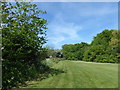
Gidea Park
The small Gidea Park is located just to the west of Gallows Corner and is sandwiched between the A12 (Eastern Avenue East) and the A118 (Main Road). This is the north-western corner. The noisy A12 is to the right here.
Image: © Marathon
Taken: 10 May 2017
0.22 miles
3
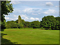
Course, Romford Golf Club
From the public footpath that crosses the course.
Image: © Robin Webster
Taken: 30 Jun 2012
0.25 miles
4
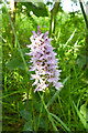
Common Spotted Orchid near A12
Near the footpath running across the golf course to the A12.
Image: © Robin Webster
Taken: 30 Jun 2012
0.25 miles